You are here: Home > Network List > UU - University of Utah Regional Network Stations List
> Station NLU North Lily, UT, USA > Earthquake Result Viewer
NLU North Lily, UT, USA - Earthquake Result Viewer
| Earthquake location: |
South Of Fiji Islands |
| Earthquake latitude/longitude: |
-22.0/-178.2 |
| Earthquake time(UTC): |
2016/05/28 (149) 05:38:51 GMT |
| Earthquake Depth: |
417 km |
| Earthquake Magnitude: |
6.6 MO |
| Earthquake Catalog/Contributor: |
NEIC PDE/NEIC ALERT |
|
| Network: |
UU University of Utah Regional Network |
| Station: |
NLU North Lily, UT, USA |
| Lat/Lon: |
39.95 N/112.07 W |
| Elevation: |
2036 m |
|
| Distance: |
87.1 deg |
| Az: |
44.715 deg |
| Baz: |
238.141 deg |
| Ray Param: |
0.042478032 |
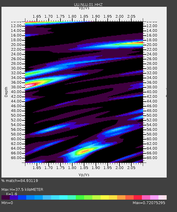
| Estimated Moho Depth: |
37.5 km |
| Estimated Crust Vp/Vs: |
1.60 |
| Assumed Crust Vp: |
6.276 km/s |
| Estimated Crust Vs: |
3.922 km/s |
| Estimated Crust Poisson's Ratio: |
0.18 |
|
| Radial Match: |
84.93119 % |
| Radial Bump: |
400 |
| Transverse Match: |
78.92902 % |
| Transverse Bump: |
364 |
| SOD ConfigId: |
1475611 |
| Insert Time: |
2016-06-11 05:47:48.437 +0000 |
| GWidth: |
2.5 |
| Max Bumps: |
400 |
| Tol: |
0.001 |
|

Signal To Noise
| Channel | StoN | STA | LTA |
| UU:NLU:01:HHZ:20160528T05:50:19.799988Z | 32.32438 | 9.2324086E-8 | 2.856175E-9 |
| UU:NLU:01:HHN:20160528T05:50:19.799988Z | 4.6421056 | 9.246567E-9 | 1.9918907E-9 |
| UU:NLU:01:HHE:20160528T05:50:19.799988Z | 9.342662 | 2.3931676E-8 | 2.5615479E-9 |
| Arrivals |
| Ps | 3.7 SECOND |
| PpPs | 15 SECOND |
| PsPs/PpSs | 19 SECOND |


