You are here: Home > Network List > TA - USArray Transportable Network (new EarthScope stations) Stations List
> Station D17A Six Diamond Ranch, Ranyesford, MT, USA > Earthquake Result Viewer
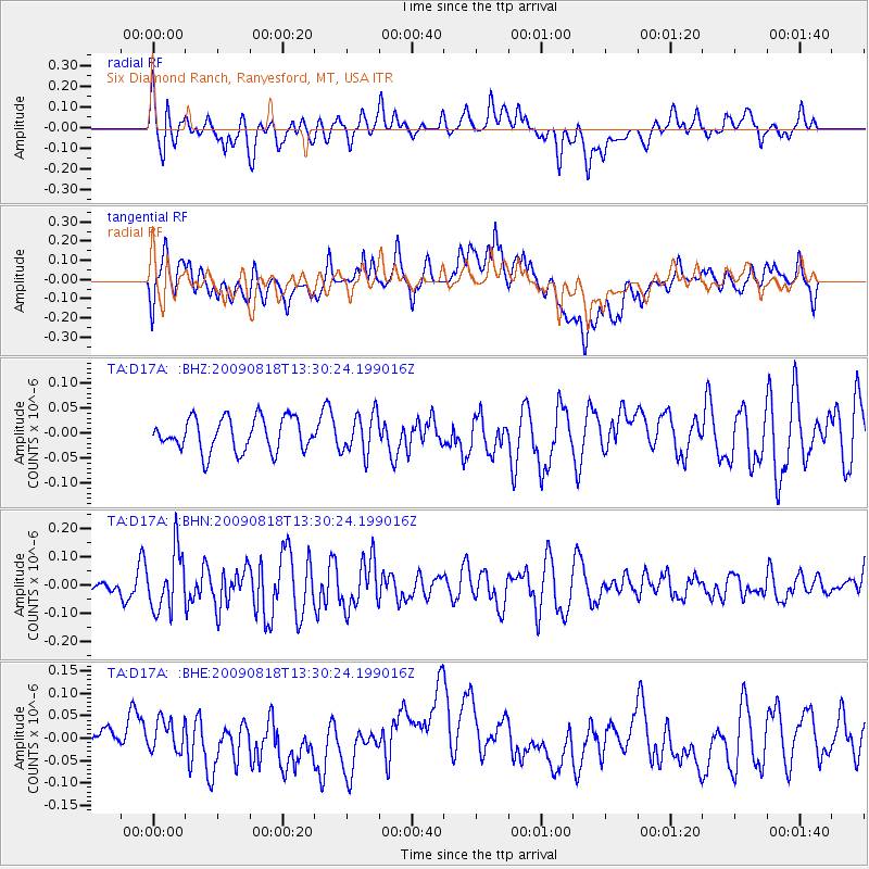
D17A Six Diamond Ranch, Ranyesford, MT, USA - Earthquake Result Viewer
*The percent match for this event was below the threshold and hence no stack was calculated.
| Earthquake location: |
Southwestern Ryukyu Isl., Japan |
| Earthquake latitude/longitude: |
23.5/123.5 |
| Earthquake time(UTC): |
2009/08/18 (230) 13:17:35 GMT |
| Earthquake Depth: |
5.7 km |
| Earthquake Magnitude: |
5.6 MB, 5.2 MS |
| Earthquake Catalog/Contributor: |
WHDF/NEIC |
|
| Network: |
TA USArray Transportable Network (new EarthScope stations) |
| Station: |
D17A Six Diamond Ranch, Ranyesford, MT, USA |
| Lat/Lon: |
47.15 N/110.69 W |
| Elevation: |
1535 m |
|
| Distance: |
94.4 deg |
| Az: |
33.725 deg |
| Baz: |
311.691 deg |
| Ray Param: |
$rayparam |
*The percent match for this event was below the threshold and hence was not used in the summary stack. |
|
| Radial Match: |
62.683125 % |
| Radial Bump: |
400 |
| Transverse Match: |
57.60671 % |
| Transverse Bump: |
400 |
| SOD ConfigId: |
2622 |
| Insert Time: |
2010-03-06 11:53:57.951 +0000 |
| GWidth: |
2.5 |
| Max Bumps: |
400 |
| Tol: |
0.001 |
|
Signal To Noise
| Channel | StoN | STA | LTA |
| TA:D17A: :BHN:20090818T13:30:24.199016Z | 2.4133537 | 1.0387369E-7 | 4.3041222E-8 |
| TA:D17A: :BHE:20090818T13:30:24.199016Z | 1.0597562 | 3.3847286E-8 | 3.193875E-8 |
| TA:D17A: :BHZ:20090818T13:30:24.199016Z | 1.2085676 | 3.989704E-8 | 3.3011837E-8 |
| Arrivals |
| Ps | |
| PpPs | |
| PsPs/PpSs | |


