You are here: Home > Network List > JP - Japan Meteorological Agency Seismic Network Stations List
> Station JTU Tsushima Kamiagata > Earthquake Result Viewer
JTU Tsushima Kamiagata - Earthquake Result Viewer
| Earthquake location: |
Vanuatu Islands |
| Earthquake latitude/longitude: |
-17.8/168.0 |
| Earthquake time(UTC): |
2018/06/21 (172) 21:13:32 GMT |
| Earthquake Depth: |
22 km |
| Earthquake Magnitude: |
6.1 Mww |
| Earthquake Catalog/Contributor: |
NEIC PDE/us |
|
| Network: |
JP Japan Meteorological Agency Seismic Network |
| Station: |
JTU Tsushima Kamiagata |
| Lat/Lon: |
34.53 N/129.40 E |
| Elevation: |
70 m |
|
| Distance: |
63.7 deg |
| Az: |
324.913 deg |
| Baz: |
138.452 deg |
| Ray Param: |
0.059370875 |
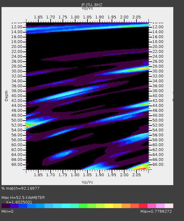
| Estimated Moho Depth: |
52.5 km |
| Estimated Crust Vp/Vs: |
1.60 |
| Assumed Crust Vp: |
6.472 km/s |
| Estimated Crust Vs: |
4.039 km/s |
| Estimated Crust Poisson's Ratio: |
0.18 |
|
| Radial Match: |
92.16977 % |
| Radial Bump: |
306 |
| Transverse Match: |
74.77009 % |
| Transverse Bump: |
400 |
| SOD ConfigId: |
13570011 |
| Insert Time: |
2019-04-30 10:31:58.045 +0000 |
| GWidth: |
2.5 |
| Max Bumps: |
400 |
| Tol: |
0.001 |
|

Signal To Noise
| Channel | StoN | STA | LTA |
| JP:JTU: :BHZ:20180621T21:23:30.70002Z | 10.646514 | 1.1698587E-6 | 1.0988185E-7 |
| JP:JTU: :BHN:20180621T21:23:30.70002Z | 12.393662 | 1.0607295E-6 | 8.558644E-8 |
| JP:JTU: :BHE:20180621T21:23:30.70002Z | 6.757773 | 8.382605E-7 | 1.2404391E-7 |
| Arrivals |
| Ps | 5.1 SECOND |
| PpPs | 20 SECOND |
| PsPs/PpSs | 25 SECOND |


