You are here: Home > Network List > TA - USArray Transportable Network (new EarthScope stations) Stations List
> Station D17A Six Diamond Ranch, Ranyesford, MT, USA > Earthquake Result Viewer
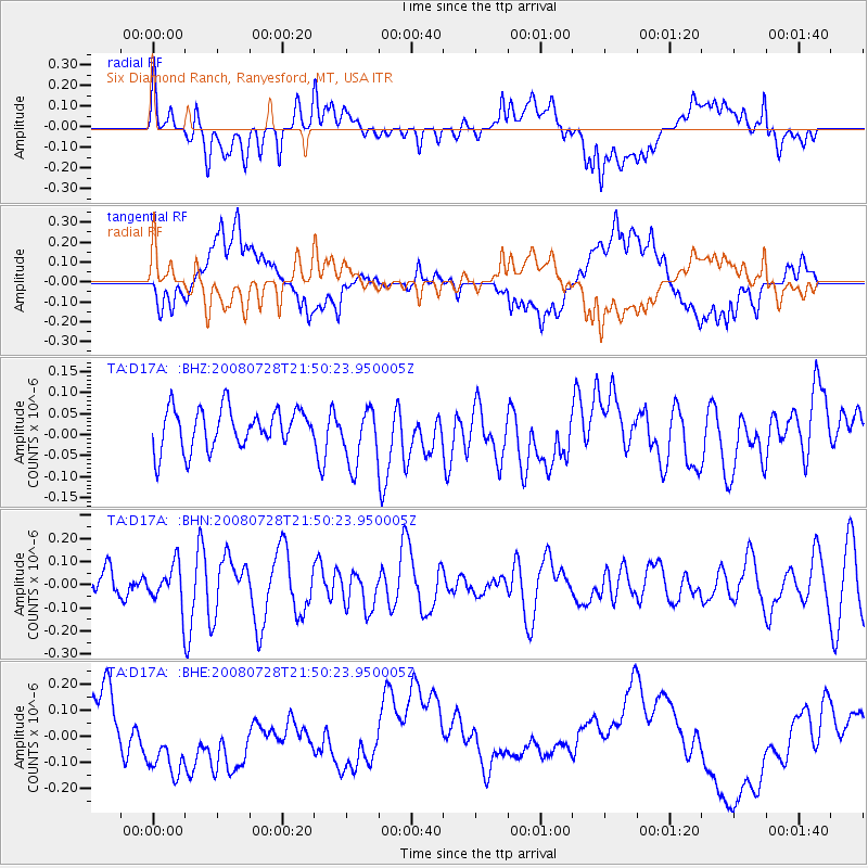
D17A Six Diamond Ranch, Ranyesford, MT, USA - Earthquake Result Viewer
*The percent match for this event was below the threshold and hence no stack was calculated.
| Earthquake location: |
Solomon Islands |
| Earthquake latitude/longitude: |
-10.6/163.2 |
| Earthquake time(UTC): |
2008/07/28 (210) 21:37:32 GMT |
| Earthquake Depth: |
10 km |
| Earthquake Magnitude: |
5.7 MB, 6.1 MS, 5.9 MW |
| Earthquake Catalog/Contributor: |
WHDF/NEIC |
|
| Network: |
TA USArray Transportable Network (new EarthScope stations) |
| Station: |
D17A Six Diamond Ranch, Ranyesford, MT, USA |
| Lat/Lon: |
47.15 N/110.69 W |
| Elevation: |
1535 m |
|
| Distance: |
95.1 deg |
| Az: |
43.13 deg |
| Baz: |
259.995 deg |
| Ray Param: |
$rayparam |
*The percent match for this event was below the threshold and hence was not used in the summary stack. |
|
| Radial Match: |
50.447853 % |
| Radial Bump: |
400 |
| Transverse Match: |
30.198387 % |
| Transverse Bump: |
400 |
| SOD ConfigId: |
2658 |
| Insert Time: |
2010-03-06 11:54:35.195 +0000 |
| GWidth: |
2.5 |
| Max Bumps: |
400 |
| Tol: |
0.001 |
|
Signal To Noise
| Channel | StoN | STA | LTA |
| TA:D17A: :BHN:20080728T21:50:23.950005Z | 1.1145864 | 8.654761E-8 | 7.764998E-8 |
| TA:D17A: :BHE:20080728T21:50:23.950005Z | 2.3932817 | 1.6541593E-7 | 6.911678E-8 |
| TA:D17A: :BHZ:20080728T21:50:23.950005Z | 1.4494228 | 6.8122716E-8 | 4.699989E-8 |
| Arrivals |
| Ps | |
| PpPs | |
| PsPs/PpSs | |


