You are here: Home > Network List > TA - USArray Transportable Network (new EarthScope stations) Stations List
> Station F19K Shaleruckik Mountain, AK, USA > Earthquake Result Viewer
F19K Shaleruckik Mountain, AK, USA - Earthquake Result Viewer
| Earthquake location: |
Vanuatu Islands |
| Earthquake latitude/longitude: |
-17.8/168.0 |
| Earthquake time(UTC): |
2018/06/21 (172) 21:13:32 GMT |
| Earthquake Depth: |
22 km |
| Earthquake Magnitude: |
6.1 Mww |
| Earthquake Catalog/Contributor: |
NEIC PDE/us |
|
| Network: |
TA USArray Transportable Network (new EarthScope stations) |
| Station: |
F19K Shaleruckik Mountain, AK, USA |
| Lat/Lon: |
66.83 N/157.77 W |
| Elevation: |
161 m |
|
| Distance: |
88.1 deg |
| Az: |
12.858 deg |
| Baz: |
212.398 deg |
| Ray Param: |
0.042783994 |
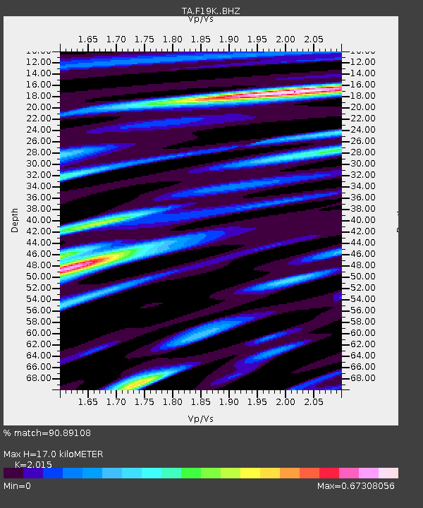
| Estimated Moho Depth: |
17.0 km |
| Estimated Crust Vp/Vs: |
2.02 |
| Assumed Crust Vp: |
6.577 km/s |
| Estimated Crust Vs: |
3.264 km/s |
| Estimated Crust Poisson's Ratio: |
0.34 |
|
| Radial Match: |
90.89108 % |
| Radial Bump: |
400 |
| Transverse Match: |
82.94635 % |
| Transverse Bump: |
400 |
| SOD ConfigId: |
13570011 |
| Insert Time: |
2019-04-30 10:33:59.259 +0000 |
| GWidth: |
2.5 |
| Max Bumps: |
400 |
| Tol: |
0.001 |
|

Signal To Noise
| Channel | StoN | STA | LTA |
| TA:F19K: :BHZ:20180621T21:25:49.274971Z | 26.179234 | 1.513464E-6 | 5.7811622E-8 |
| TA:F19K: :BHN:20180621T21:25:49.274971Z | 7.616413 | 4.0355206E-7 | 5.298453E-8 |
| TA:F19K: :BHE:20180621T21:25:49.274971Z | 4.844403 | 3.3762316E-7 | 6.9693456E-8 |
| Arrivals |
| Ps | 2.7 SECOND |
| PpPs | 7.6 SECOND |
| PsPs/PpSs | 10 SECOND |


