You are here: Home > Network List > TA - USArray Transportable Network (new EarthScope stations) Stations List
> Station F21K Alatna River, AK, USA > Earthquake Result Viewer
F21K Alatna River, AK, USA - Earthquake Result Viewer
| Earthquake location: |
Vanuatu Islands |
| Earthquake latitude/longitude: |
-17.8/168.0 |
| Earthquake time(UTC): |
2018/06/21 (172) 21:13:32 GMT |
| Earthquake Depth: |
22 km |
| Earthquake Magnitude: |
6.1 Mww |
| Earthquake Catalog/Contributor: |
NEIC PDE/us |
|
| Network: |
TA USArray Transportable Network (new EarthScope stations) |
| Station: |
F21K Alatna River, AK, USA |
| Lat/Lon: |
67.22 N/153.48 W |
| Elevation: |
597 m |
|
| Distance: |
89.4 deg |
| Az: |
14.027 deg |
| Baz: |
216.368 deg |
| Ray Param: |
0.04184513 |
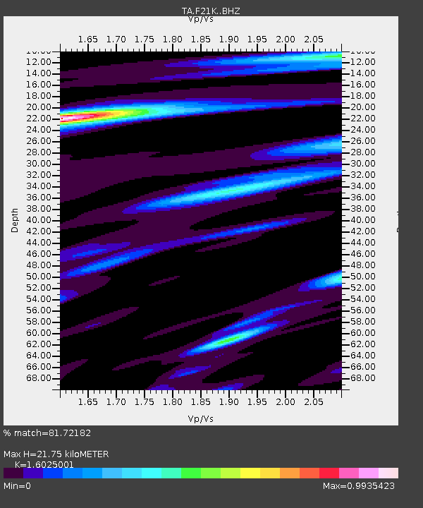
| Estimated Moho Depth: |
21.75 km |
| Estimated Crust Vp/Vs: |
1.60 |
| Assumed Crust Vp: |
6.455 km/s |
| Estimated Crust Vs: |
4.028 km/s |
| Estimated Crust Poisson's Ratio: |
0.18 |
|
| Radial Match: |
81.72182 % |
| Radial Bump: |
400 |
| Transverse Match: |
73.971245 % |
| Transverse Bump: |
400 |
| SOD ConfigId: |
13570011 |
| Insert Time: |
2019-04-30 10:34:02.120 +0000 |
| GWidth: |
2.5 |
| Max Bumps: |
400 |
| Tol: |
0.001 |
|

Signal To Noise
| Channel | StoN | STA | LTA |
| TA:F21K: :BHZ:20180621T21:25:55.250007Z | 13.67308 | 7.8080114E-7 | 5.710499E-8 |
| TA:F21K: :BHN:20180621T21:25:55.250007Z | 4.1493297 | 1.73283E-7 | 4.1761684E-8 |
| TA:F21K: :BHE:20180621T21:25:55.250007Z | 2.8400676 | 1.2271298E-7 | 4.3207766E-8 |
| Arrivals |
| Ps | 2.1 SECOND |
| PpPs | 8.6 SECOND |
| PsPs/PpSs | 11 SECOND |


