You are here: Home > Network List > CU - Caribbean Network (USGS) Stations List
> Station BBGH Gun Hill, Barbados > Earthquake Result Viewer
BBGH Gun Hill, Barbados - Earthquake Result Viewer
| Earthquake location: |
South Sandwich Islands Region |
| Earthquake latitude/longitude: |
-56.2/-26.9 |
| Earthquake time(UTC): |
2016/05/28 (149) 09:46:59 GMT |
| Earthquake Depth: |
73 km |
| Earthquake Magnitude: |
7.2 MWW, 7.3 MI |
| Earthquake Catalog/Contributor: |
NEIC PDE/NEIC COMCAT |
|
| Network: |
CU Caribbean Network (USGS) |
| Station: |
BBGH Gun Hill, Barbados |
| Lat/Lon: |
13.14 N/59.56 W |
| Elevation: |
180 m |
|
| Distance: |
74.3 deg |
| Az: |
326.893 deg |
| Baz: |
161.739 deg |
| Ray Param: |
0.05227825 |
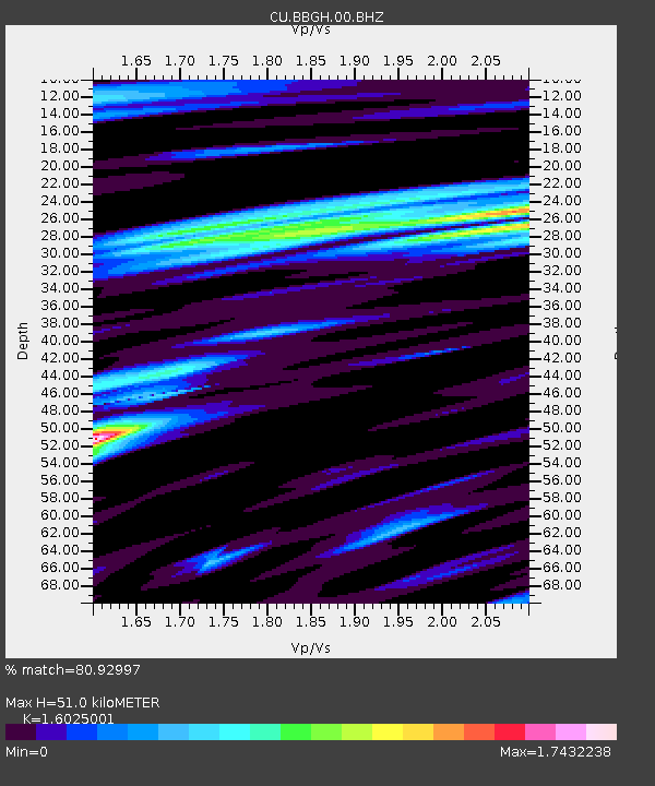
| Estimated Moho Depth: |
51.0 km |
| Estimated Crust Vp/Vs: |
1.60 |
| Assumed Crust Vp: |
4.438 km/s |
| Estimated Crust Vs: |
2.769 km/s |
| Estimated Crust Poisson's Ratio: |
0.18 |
|
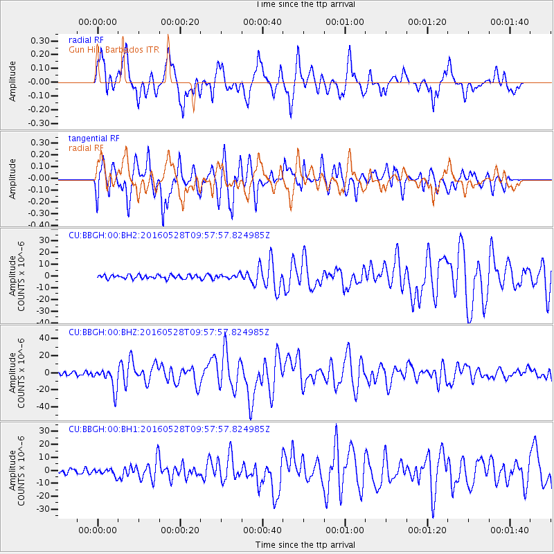
| Radial Match: |
80.92997 % |
| Radial Bump: |
400 |
| Transverse Match: |
72.996826 % |
| Transverse Bump: |
400 |
| SOD ConfigId: |
1475611 |
| Insert Time: |
2016-06-11 09:48:12.334 +0000 |
| GWidth: |
2.5 |
| Max Bumps: |
400 |
| Tol: |
0.001 |
|
Signal To Noise
| Channel | StoN | STA | LTA |
| CU:BBGH:00:BHZ:20160528T09:57:57.824985Z | 5.1177926 | 1.3263309E-5 | 2.5916074E-6 |
| CU:BBGH:00:BH1:20160528T09:57:57.824985Z | 1.3149638 | 2.6534585E-6 | 2.0178948E-6 |
| CU:BBGH:00:BH2:20160528T09:57:57.824985Z | 1.0973012 | 1.7130466E-6 | 1.5611453E-6 |
| Arrivals |
| Ps | 7.0 SECOND |
| PpPs | 29 SECOND |
| PsPs/PpSs | 36 SECOND |


