You are here: Home > Network List > TA - USArray Transportable Network (new EarthScope stations) Stations List
> Station M19K Big River Lodge, Big River, AK, USA > Earthquake Result Viewer
M19K Big River Lodge, Big River, AK, USA - Earthquake Result Viewer
| Earthquake location: |
Vanuatu Islands |
| Earthquake latitude/longitude: |
-17.8/168.0 |
| Earthquake time(UTC): |
2018/06/21 (172) 21:13:32 GMT |
| Earthquake Depth: |
22 km |
| Earthquake Magnitude: |
6.1 Mww |
| Earthquake Catalog/Contributor: |
NEIC PDE/us |
|
| Network: |
TA USArray Transportable Network (new EarthScope stations) |
| Station: |
M19K Big River Lodge, Big River, AK, USA |
| Lat/Lon: |
61.90 N/154.39 W |
| Elevation: |
521 m |
|
| Distance: |
84.9 deg |
| Az: |
16.853 deg |
| Baz: |
215.689 deg |
| Ray Param: |
0.045153774 |
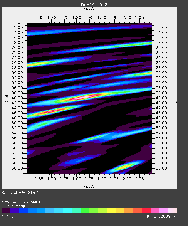
| Estimated Moho Depth: |
39.5 km |
| Estimated Crust Vp/Vs: |
1.83 |
| Assumed Crust Vp: |
6.566 km/s |
| Estimated Crust Vs: |
3.593 km/s |
| Estimated Crust Poisson's Ratio: |
0.29 |
|
| Radial Match: |
90.31627 % |
| Radial Bump: |
400 |
| Transverse Match: |
85.964676 % |
| Transverse Bump: |
400 |
| SOD ConfigId: |
13570011 |
| Insert Time: |
2019-04-30 10:35:04.837 +0000 |
| GWidth: |
2.5 |
| Max Bumps: |
400 |
| Tol: |
0.001 |
|

Signal To Noise
| Channel | StoN | STA | LTA |
| TA:M19K: :BHZ:20180621T21:25:33.274971Z | 25.712128 | 1.8839155E-6 | 7.326953E-8 |
| TA:M19K: :BHN:20180621T21:25:33.274971Z | 9.709087 | 5.724117E-7 | 5.895628E-8 |
| TA:M19K: :BHE:20180621T21:25:33.274971Z | 11.556363 | 5.0934693E-7 | 4.407502E-8 |
| Arrivals |
| Ps | 5.1 SECOND |
| PpPs | 17 SECOND |
| PsPs/PpSs | 22 SECOND |


