You are here: Home > Network List > TA - USArray Transportable Network (new EarthScope stations) Stations List
> Station M23K Glacier View, AK, USA > Earthquake Result Viewer
M23K Glacier View, AK, USA - Earthquake Result Viewer
| Earthquake location: |
Vanuatu Islands |
| Earthquake latitude/longitude: |
-17.8/168.0 |
| Earthquake time(UTC): |
2018/06/21 (172) 21:13:32 GMT |
| Earthquake Depth: |
22 km |
| Earthquake Magnitude: |
6.1 Mww |
| Earthquake Catalog/Contributor: |
NEIC PDE/us |
|
| Network: |
TA USArray Transportable Network (new EarthScope stations) |
| Station: |
M23K Glacier View, AK, USA |
| Lat/Lon: |
61.79 N/147.73 W |
| Elevation: |
583 m |
|
| Distance: |
86.8 deg |
| Az: |
19.395 deg |
| Baz: |
221.744 deg |
| Ray Param: |
0.04379869 |
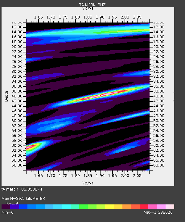
| Estimated Moho Depth: |
39.5 km |
| Estimated Crust Vp/Vs: |
1.90 |
| Assumed Crust Vp: |
6.566 km/s |
| Estimated Crust Vs: |
3.456 km/s |
| Estimated Crust Poisson's Ratio: |
0.31 |
|
| Radial Match: |
86.853874 % |
| Radial Bump: |
400 |
| Transverse Match: |
65.062325 % |
| Transverse Bump: |
400 |
| SOD ConfigId: |
13570011 |
| Insert Time: |
2019-04-30 10:35:10.706 +0000 |
| GWidth: |
2.5 |
| Max Bumps: |
400 |
| Tol: |
0.001 |
|

Signal To Noise
| Channel | StoN | STA | LTA |
| TA:M23K: :BHZ:20180621T21:25:42.599983Z | 11.81533 | 9.28527E-7 | 7.858664E-8 |
| TA:M23K: :BHN:20180621T21:25:42.599983Z | 3.3340206 | 2.37298E-7 | 7.1174725E-8 |
| TA:M23K: :BHE:20180621T21:25:42.599983Z | 2.9913688 | 2.1751126E-7 | 7.271296E-8 |
| Arrivals |
| Ps | 5.5 SECOND |
| PpPs | 17 SECOND |
| PsPs/PpSs | 23 SECOND |


