You are here: Home > Network List > TA - USArray Transportable Network (new EarthScope stations) Stations List
> Station N15K Kwethluk River, AK, USA > Earthquake Result Viewer
N15K Kwethluk River, AK, USA - Earthquake Result Viewer
| Earthquake location: |
Vanuatu Islands |
| Earthquake latitude/longitude: |
-17.8/168.0 |
| Earthquake time(UTC): |
2018/06/21 (172) 21:13:32 GMT |
| Earthquake Depth: |
22 km |
| Earthquake Magnitude: |
6.1 Mww |
| Earthquake Catalog/Contributor: |
NEIC PDE/us |
|
| Network: |
TA USArray Transportable Network (new EarthScope stations) |
| Station: |
N15K Kwethluk River, AK, USA |
| Lat/Lon: |
60.17 N/160.09 W |
| Elevation: |
449 m |
|
| Distance: |
81.9 deg |
| Az: |
15.471 deg |
| Baz: |
210.549 deg |
| Ray Param: |
0.047244295 |
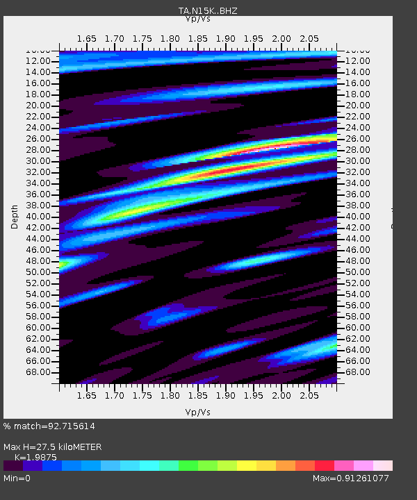
| Estimated Moho Depth: |
27.5 km |
| Estimated Crust Vp/Vs: |
1.99 |
| Assumed Crust Vp: |
6.182 km/s |
| Estimated Crust Vs: |
3.111 km/s |
| Estimated Crust Poisson's Ratio: |
0.33 |
|
| Radial Match: |
92.715614 % |
| Radial Bump: |
367 |
| Transverse Match: |
83.858604 % |
| Transverse Bump: |
400 |
| SOD ConfigId: |
13570011 |
| Insert Time: |
2019-04-30 10:35:16.468 +0000 |
| GWidth: |
2.5 |
| Max Bumps: |
400 |
| Tol: |
0.001 |
|

Signal To Noise
| Channel | StoN | STA | LTA |
| TA:N15K: :BHZ:20180621T21:25:18.024971Z | 23.735352 | 1.8747992E-6 | 7.8987625E-8 |
| TA:N15K: :BHN:20180621T21:25:18.024971Z | 12.154206 | 6.534699E-7 | 5.3764918E-8 |
| TA:N15K: :BHE:20180621T21:25:18.024971Z | 6.34819 | 4.7255762E-7 | 7.443974E-8 |
| Arrivals |
| Ps | 4.5 SECOND |
| PpPs | 13 SECOND |
| PsPs/PpSs | 17 SECOND |


