You are here: Home > Network List > TA - USArray Transportable Network (new EarthScope stations) Stations List
> Station U33K Whale Pass, AK, USA > Earthquake Result Viewer
U33K Whale Pass, AK, USA - Earthquake Result Viewer
| Earthquake location: |
Vanuatu Islands |
| Earthquake latitude/longitude: |
-17.8/168.0 |
| Earthquake time(UTC): |
2018/06/21 (172) 21:13:32 GMT |
| Earthquake Depth: |
22 km |
| Earthquake Magnitude: |
6.1 Mww |
| Earthquake Catalog/Contributor: |
NEIC PDE/us |
|
| Network: |
TA USArray Transportable Network (new EarthScope stations) |
| Station: |
U33K Whale Pass, AK, USA |
| Lat/Lon: |
56.11 N/133.12 W |
| Elevation: |
11 m |
|
| Distance: |
88.6 deg |
| Az: |
28.654 deg |
| Baz: |
234.643 deg |
| Ray Param: |
0.042426687 |
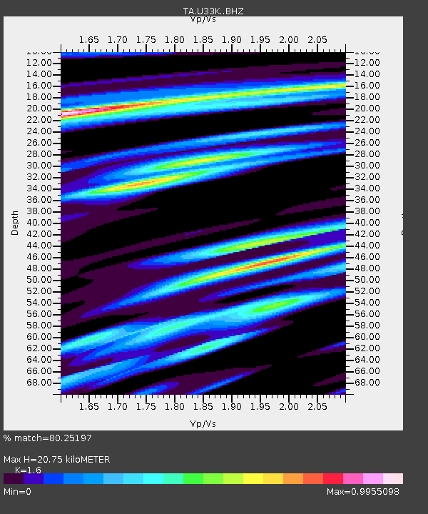
| Estimated Moho Depth: |
20.75 km |
| Estimated Crust Vp/Vs: |
1.60 |
| Assumed Crust Vp: |
6.597 km/s |
| Estimated Crust Vs: |
4.123 km/s |
| Estimated Crust Poisson's Ratio: |
0.18 |
|
| Radial Match: |
80.25197 % |
| Radial Bump: |
400 |
| Transverse Match: |
69.4775 % |
| Transverse Bump: |
400 |
| SOD ConfigId: |
13570011 |
| Insert Time: |
2019-04-30 10:35:52.761 +0000 |
| GWidth: |
2.5 |
| Max Bumps: |
400 |
| Tol: |
0.001 |
|

Signal To Noise
| Channel | StoN | STA | LTA |
| TA:U33K: :BHZ:20180621T21:25:51.524971Z | 7.3683724 | 8.801327E-7 | 1.1944736E-7 |
| TA:U33K: :BHN:20180621T21:25:51.524971Z | 2.9012773 | 1.6664839E-7 | 5.743966E-8 |
| TA:U33K: :BHE:20180621T21:25:51.524971Z | 2.438055 | 2.8976373E-7 | 1.18850366E-7 |
| Arrivals |
| Ps | 1.9 SECOND |
| PpPs | 8.0 SECOND |
| PsPs/PpSs | 9.9 SECOND |


