You are here: Home > Network List > TA - USArray Transportable Network (new EarthScope stations) Stations List
> Station J08A Circle Bar Ranch, Crane, OR, USA > Earthquake Result Viewer
J08A Circle Bar Ranch, Crane, OR, USA - Earthquake Result Viewer
| Earthquake location: |
South Of Fiji Islands |
| Earthquake latitude/longitude: |
-26.0/-177.5 |
| Earthquake time(UTC): |
2007/12/09 (343) 07:28:20 GMT |
| Earthquake Depth: |
152 km |
| Earthquake Magnitude: |
7.0 MB, 7.8 MW, 7.7 MW |
| Earthquake Catalog/Contributor: |
WHDF/NEIC |
|
| Network: |
TA USArray Transportable Network (new EarthScope stations) |
| Station: |
J08A Circle Bar Ranch, Crane, OR, USA |
| Lat/Lon: |
43.36 N/118.47 W |
| Elevation: |
1229 m |
|
| Distance: |
87.7 deg |
| Az: |
38.752 deg |
| Baz: |
230.566 deg |
| Ray Param: |
0.042762596 |
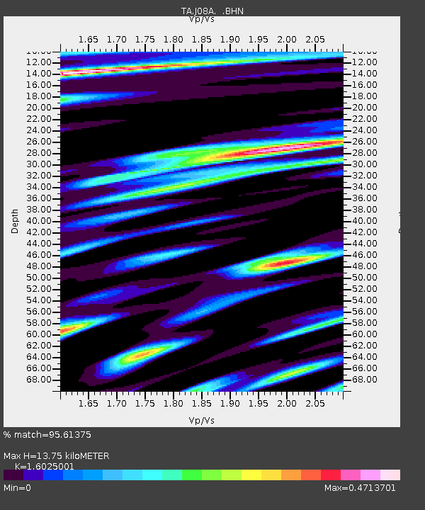
| Estimated Moho Depth: |
13.75 km |
| Estimated Crust Vp/Vs: |
1.60 |
| Assumed Crust Vp: |
6.279 km/s |
| Estimated Crust Vs: |
3.918 km/s |
| Estimated Crust Poisson's Ratio: |
0.18 |
|
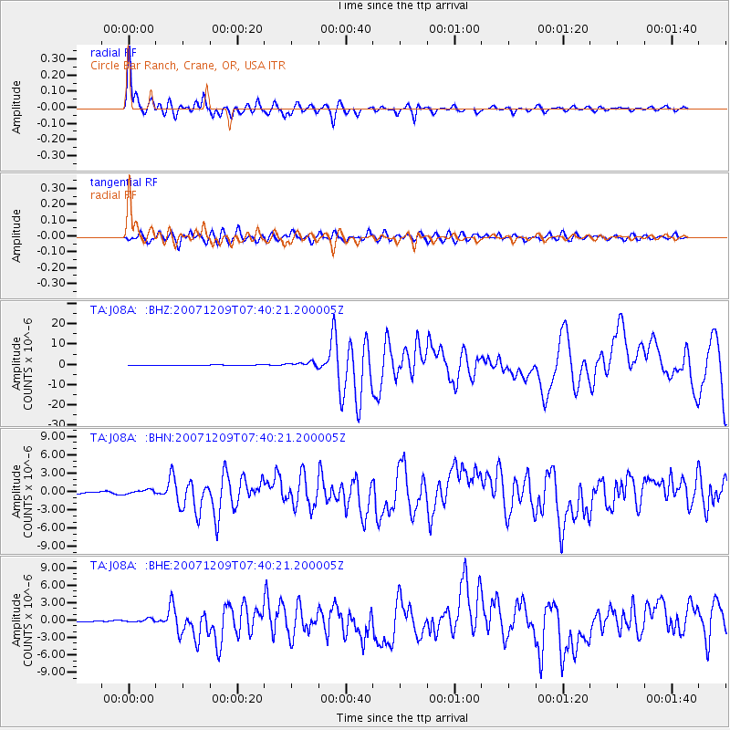
| Radial Match: |
95.61375 % |
| Radial Bump: |
400 |
| Transverse Match: |
90.04546 % |
| Transverse Bump: |
400 |
| SOD ConfigId: |
2564 |
| Insert Time: |
2010-03-06 11:55:34.693 +0000 |
| GWidth: |
2.5 |
| Max Bumps: |
400 |
| Tol: |
0.001 |
|
Signal To Noise
| Channel | StoN | STA | LTA |
| TA:J08A: :BHN:20071209T07:40:21.200005Z | 1.811266 | 3.8963182E-7 | 2.1511573E-7 |
| TA:J08A: :BHE:20071209T07:40:21.200005Z | 2.2541862 | 3.4448266E-7 | 1.5281908E-7 |
| TA:J08A: :BHZ:20071209T07:40:21.200005Z | 7.5576262 | 1.139517E-6 | 1.5077711E-7 |
| Arrivals |
| Ps | 1.4 SECOND |
| PpPs | 5.6 SECOND |
| PsPs/PpSs | 6.9 SECOND |


