You are here: Home > Network List > UW - Pacific Northwest Regional Seismic Network Stations List
> Station FISH Seaside, OR, USA > Earthquake Result Viewer
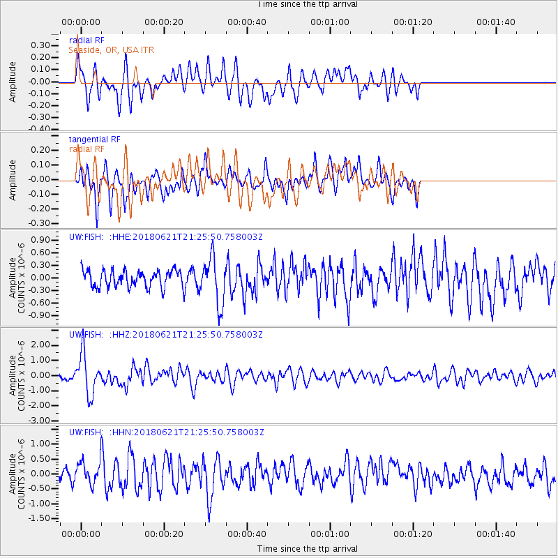
FISH Seaside, OR, USA - Earthquake Result Viewer
*The percent match for this event was below the threshold and hence no stack was calculated.
| Earthquake location: |
Vanuatu Islands |
| Earthquake latitude/longitude: |
-17.8/168.0 |
| Earthquake time(UTC): |
2018/06/21 (172) 21:13:32 GMT |
| Earthquake Depth: |
22 km |
| Earthquake Magnitude: |
6.1 Mww |
| Earthquake Catalog/Contributor: |
NEIC PDE/us |
|
| Network: |
UW Pacific Northwest Regional Seismic Network |
| Station: |
FISH Seaside, OR, USA |
| Lat/Lon: |
45.93 N/123.56 W |
| Elevation: |
325 m |
|
| Distance: |
88.5 deg |
| Az: |
40.484 deg |
| Baz: |
242.394 deg |
| Ray Param: |
$rayparam |
*The percent match for this event was below the threshold and hence was not used in the summary stack. |
|
| Radial Match: |
71.118286 % |
| Radial Bump: |
400 |
| Transverse Match: |
64.00787 % |
| Transverse Bump: |
400 |
| SOD ConfigId: |
13570011 |
| Insert Time: |
2019-04-30 10:36:38.094 +0000 |
| GWidth: |
2.5 |
| Max Bumps: |
400 |
| Tol: |
0.001 |
|
Signal To Noise
| Channel | StoN | STA | LTA |
| UW:FISH: :HHZ:20180621T21:25:50.758003Z | 9.280794 | 1.3791654E-6 | 1.4860424E-7 |
| UW:FISH: :HHN:20180621T21:25:50.758003Z | 2.326087 | 4.3133966E-7 | 1.8543575E-7 |
| UW:FISH: :HHE:20180621T21:25:50.758003Z | 3.021411 | 5.8818273E-7 | 1.9467154E-7 |
| Arrivals |
| Ps | |
| PpPs | |
| PsPs/PpSs | |


