You are here: Home > Network List > TA - USArray Transportable Network (new EarthScope stations) Stations List
> Station J08A Circle Bar Ranch, Crane, OR, USA > Earthquake Result Viewer
J08A Circle Bar Ranch, Crane, OR, USA - Earthquake Result Viewer
| Earthquake location: |
Jujuy Province, Argentina |
| Earthquake latitude/longitude: |
-22.6/-66.3 |
| Earthquake time(UTC): |
2007/11/18 (322) 05:40:12 GMT |
| Earthquake Depth: |
246 km |
| Earthquake Magnitude: |
5.7 MB, 6.0 MW, 6.0 MW |
| Earthquake Catalog/Contributor: |
WHDF/NEIC |
|
| Network: |
TA USArray Transportable Network (new EarthScope stations) |
| Station: |
J08A Circle Bar Ranch, Crane, OR, USA |
| Lat/Lon: |
43.36 N/118.47 W |
| Elevation: |
1229 m |
|
| Distance: |
81.3 deg |
| Az: |
324.361 deg |
| Baz: |
132.437 deg |
| Ray Param: |
0.047064885 |
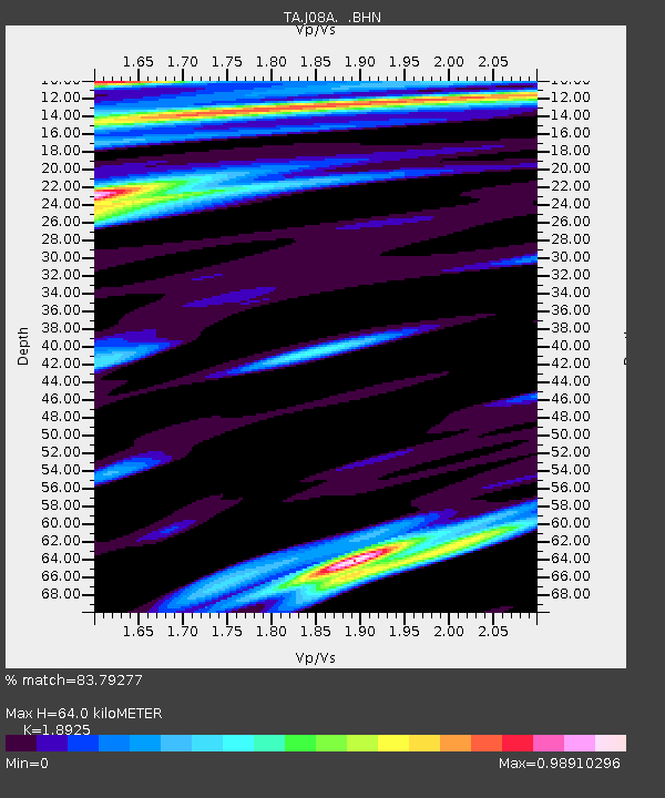
| Estimated Moho Depth: |
64.0 km |
| Estimated Crust Vp/Vs: |
1.89 |
| Assumed Crust Vp: |
6.279 km/s |
| Estimated Crust Vs: |
3.318 km/s |
| Estimated Crust Poisson's Ratio: |
0.31 |
|
| Radial Match: |
83.79277 % |
| Radial Bump: |
400 |
| Transverse Match: |
44.792526 % |
| Transverse Bump: |
400 |
| SOD ConfigId: |
2564 |
| Insert Time: |
2010-03-06 11:55:39.655 +0000 |
| GWidth: |
2.5 |
| Max Bumps: |
400 |
| Tol: |
0.001 |
|
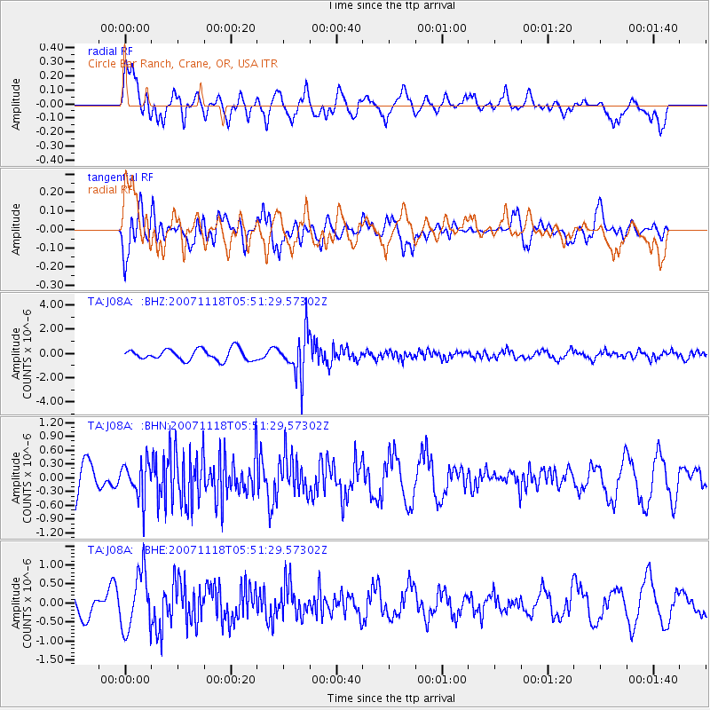
Signal To Noise
| Channel | StoN | STA | LTA |
| TA:J08A: :BHN:20071118T05:51:29.57302Z | 0.6862456 | 3.9502595E-7 | 5.7563346E-7 |
| TA:J08A: :BHE:20071118T05:51:29.57302Z | 1.8468786 | 7.755265E-7 | 4.1991197E-7 |
| TA:J08A: :BHZ:20071118T05:51:29.57302Z | 3.8253858 | 1.752541E-6 | 4.5813448E-7 |
| Arrivals |
| Ps | 9.3 SECOND |
| PpPs | 29 SECOND |
| PsPs/PpSs | 38 SECOND |


