You are here: Home > Network List > TA - USArray Transportable Network (new EarthScope stations) Stations List
> Station J08A Circle Bar Ranch, Crane, OR, USA > Earthquake Result Viewer
J08A Circle Bar Ranch, Crane, OR, USA - Earthquake Result Viewer
| Earthquake location: |
Peru-Ecuador Border Region |
| Earthquake latitude/longitude: |
-2.3/-77.8 |
| Earthquake time(UTC): |
2007/11/16 (320) 03:13:00 GMT |
| Earthquake Depth: |
123 km |
| Earthquake Magnitude: |
6.3 MB, 6.8 MW, 6.7 MW |
| Earthquake Catalog/Contributor: |
WHDF/NEIC |
|
| Network: |
TA USArray Transportable Network (new EarthScope stations) |
| Station: |
J08A Circle Bar Ranch, Crane, OR, USA |
| Lat/Lon: |
43.36 N/118.47 W |
| Elevation: |
1229 m |
|
| Distance: |
58.3 deg |
| Az: |
326.057 deg |
| Baz: |
130.099 deg |
| Ray Param: |
0.062569946 |
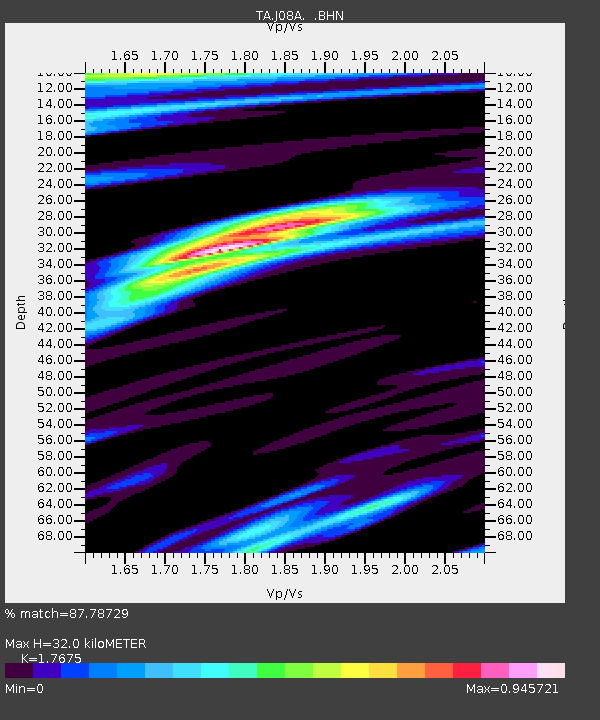
| Estimated Moho Depth: |
32.0 km |
| Estimated Crust Vp/Vs: |
1.77 |
| Assumed Crust Vp: |
6.279 km/s |
| Estimated Crust Vs: |
3.552 km/s |
| Estimated Crust Poisson's Ratio: |
0.26 |
|
| Radial Match: |
87.78729 % |
| Radial Bump: |
400 |
| Transverse Match: |
80.51169 % |
| Transverse Bump: |
400 |
| SOD ConfigId: |
2564 |
| Insert Time: |
2010-03-06 11:55:41.643 +0000 |
| GWidth: |
2.5 |
| Max Bumps: |
400 |
| Tol: |
0.001 |
|
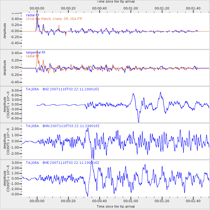
Signal To Noise
| Channel | StoN | STA | LTA |
| TA:J08A: :BHN:20071116T03:22:11.299016Z | 1.5367522 | 2.4178496E-7 | 1.5733502E-7 |
| TA:J08A: :BHE:20071116T03:22:11.299016Z | 0.5274525 | 2.8902636E-7 | 5.479666E-7 |
| TA:J08A: :BHZ:20071116T03:22:11.299016Z | 3.4065533 | 9.418945E-7 | 2.7649486E-7 |
| Arrivals |
| Ps | 4.1 SECOND |
| PpPs | 13 SECOND |
| PsPs/PpSs | 18 SECOND |


