You are here: Home > Network List > TA - USArray Transportable Network (new EarthScope stations) Stations List
> Station J08A Circle Bar Ranch, Crane, OR, USA > Earthquake Result Viewer
J08A Circle Bar Ranch, Crane, OR, USA - Earthquake Result Viewer
| Earthquake location: |
South Of Fiji Islands |
| Earthquake latitude/longitude: |
-25.8/179.5 |
| Earthquake time(UTC): |
2007/10/16 (289) 21:05:43 GMT |
| Earthquake Depth: |
509 km |
| Earthquake Magnitude: |
6.2 MB, 6.6 MW, 6.5 MW |
| Earthquake Catalog/Contributor: |
WHDF/NEIC |
|
| Network: |
TA USArray Transportable Network (new EarthScope stations) |
| Station: |
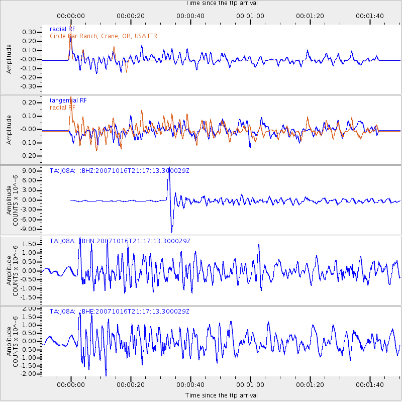
J08A Circle Bar Ranch, Crane, OR, USA |
| Lat/Lon: |
43.36 N/118.47 W |
| Elevation: |
1229 m |
|
| Distance: |
89.3 deg |
| Az: |
40.093 deg |
| Baz: |
232.763 deg |
| Ray Param: |
0.041623347 |
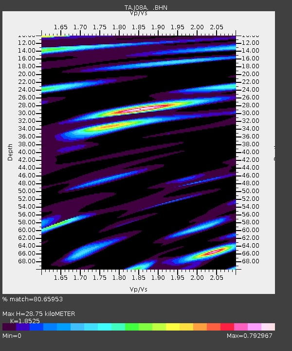
| Estimated Moho Depth: |
28.75 km |
| Estimated Crust Vp/Vs: |
1.85 |
| Assumed Crust Vp: |
6.279 km/s |
| Estimated Crust Vs: |
3.389 km/s |
| Estimated Crust Poisson's Ratio: |
0.29 |
|
| Radial Match: |
80.65953 % |
| Radial Bump: |
400 |
| Transverse Match: |
76.1171 % |
| Transverse Bump: |
400 |
| SOD ConfigId: |
2564 |
| Insert Time: |
2010-03-06 11:55:45.069 +0000 |
| GWidth: |
2.5 |
| Max Bumps: |
400 |
| Tol: |
0.001 |
|
Signal To Noise
| Channel | StoN | STA | LTA |
| TA:J08A: :BHN:20071016T21:17:13.300029Z | 5.5135164 | 6.447721E-7 | 1.1694391E-7 |
| TA:J08A: :BHE:20071016T21:17:13.300029Z | 3.8749616 | 7.9190863E-7 | 2.0436555E-7 |
| TA:J08A: :BHZ:20071016T21:17:13.300029Z | 41.823963 | 4.5255197E-6 | 1.0820399E-7 |
| Arrivals |
| Ps | 4.0 SECOND |
| PpPs | 13 SECOND |
| PsPs/PpSs | 17 SECOND |


