You are here: Home > Network List > XO18 - AACE: Alaska Amphibious Community seismic Experimen Stations List
> Station KT08 Amook, AK > Earthquake Result Viewer
KT08 Amook, AK - Earthquake Result Viewer
| Earthquake location: |
Vanuatu Islands |
| Earthquake latitude/longitude: |
-17.8/168.0 |
| Earthquake time(UTC): |
2018/06/21 (172) 21:13:32 GMT |
| Earthquake Depth: |
22 km |
| Earthquake Magnitude: |
6.1 Mww |
| Earthquake Catalog/Contributor: |
NEIC PDE/us |
|
| Network: |
XO AACE: Alaska Amphibious Community seismic Experimen |
| Station: |
KT08 Amook, AK |
| Lat/Lon: |
57.44 N/153.81 W |
| Elevation: |
41 m |
|
| Distance: |
81.4 deg |
| Az: |
19.748 deg |
| Baz: |
216.532 deg |
| Ray Param: |
0.047575273 |
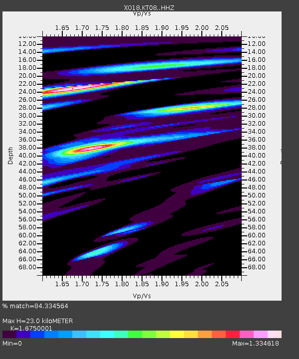
| Estimated Moho Depth: |
23.0 km |
| Estimated Crust Vp/Vs: |
1.68 |
| Assumed Crust Vp: |
6.134 km/s |
| Estimated Crust Vs: |
3.662 km/s |
| Estimated Crust Poisson's Ratio: |
0.22 |
|
| Radial Match: |
84.334564 % |
| Radial Bump: |
400 |
| Transverse Match: |
82.551476 % |
| Transverse Bump: |
400 |
| SOD ConfigId: |
13570011 |
| Insert Time: |
2019-04-30 10:37:24.639 +0000 |
| GWidth: |
2.5 |
| Max Bumps: |
400 |
| Tol: |
0.001 |
|

Signal To Noise
| Channel | StoN | STA | LTA |
| XO:KT08: :HHZ:20180621T21:25:15.539985Z | 19.502203 | 1.6870436E-6 | 8.650529E-8 |
| XO:KT08: :HHN:20180621T21:25:15.539985Z | 5.03161 | 5.1444744E-7 | 1.02243106E-7 |
| XO:KT08: :HHE:20180621T21:25:15.539985Z | 5.219651 | 5.366204E-7 | 1.0280771E-7 |
| Arrivals |
| Ps | 2.6 SECOND |
| PpPs | 9.8 SECOND |
| PsPs/PpSs | 12 SECOND |


