You are here: Home > Network List > G - GEOSCOPE Stations List
> Station RER Riviere de l'Est, La Reunion (Indian Ocean) > Earthquake Result Viewer
RER Riviere de l'Est, La Reunion (Indian Ocean) - Earthquake Result Viewer
| Earthquake location: |
South Sandwich Islands Region |
| Earthquake latitude/longitude: |
-56.2/-26.9 |
| Earthquake time(UTC): |
2016/05/28 (149) 09:46:59 GMT |
| Earthquake Depth: |
73 km |
| Earthquake Magnitude: |
7.2 MWW, 7.3 MI |
| Earthquake Catalog/Contributor: |
NEIC PDE/NEIC COMCAT |
|
| Network: |
G GEOSCOPE |
| Station: |
RER Riviere de l'Est, La Reunion (Indian Ocean) |
| Lat/Lon: |
21.16 S/55.75 E |
| Elevation: |
834 m |
|
| Distance: |
68.6 deg |
| Az: |
96.249 deg |
| Baz: |
216.523 deg |
| Ray Param: |
0.05601036 |
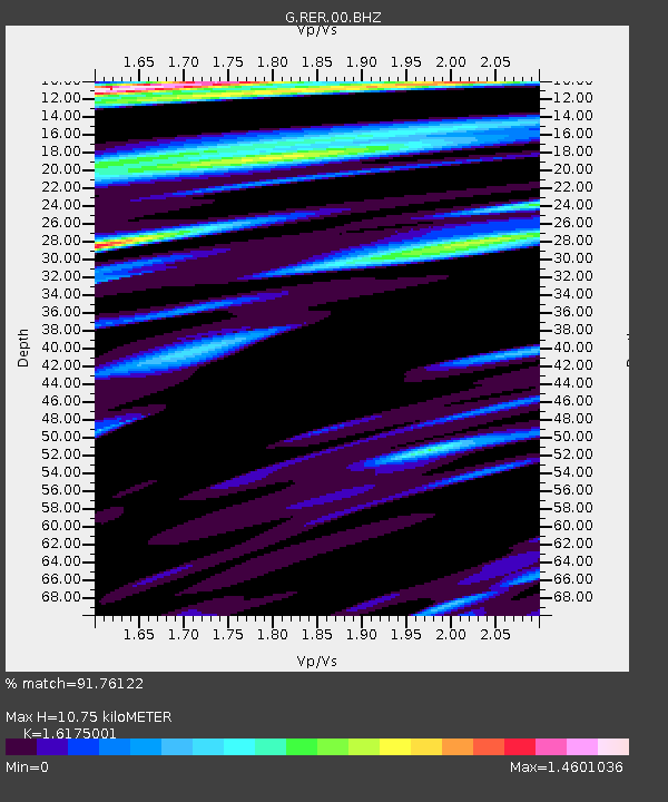
| Estimated Moho Depth: |
10.75 km |
| Estimated Crust Vp/Vs: |
1.62 |
| Assumed Crust Vp: |
4.73 km/s |
| Estimated Crust Vs: |
2.924 km/s |
| Estimated Crust Poisson's Ratio: |
0.19 |
|
| Radial Match: |
91.76122 % |
| Radial Bump: |
400 |
| Transverse Match: |
72.44558 % |
| Transverse Bump: |
400 |
| SOD ConfigId: |
1475611 |
| Insert Time: |
2016-06-11 09:50:19.197 +0000 |
| GWidth: |
2.5 |
| Max Bumps: |
400 |
| Tol: |
0.001 |
|

Signal To Noise
| Channel | StoN | STA | LTA |
| G:RER:00:BHZ:20160528T09:57:23.85001Z | 6.4340935 | 8.612544E-6 | 1.3385792E-6 |
| G:RER:00:BHN:20160528T09:57:23.85001Z | 3.761294 | 3.855588E-6 | 1.0250697E-6 |
| G:RER:00:BHE:20160528T09:57:23.85001Z | 1.6004615 | 1.8524692E-6 | 1.1574593E-6 |
| Arrivals |
| Ps | 1.4 SECOND |
| PpPs | 5.8 SECOND |
| PsPs/PpSs | 7.3 SECOND |


