You are here: Home > Network List > TA - USArray Transportable Network (new EarthScope stations) Stations List
> Station J08A Circle Bar Ranch, Crane, OR, USA > Earthquake Result Viewer
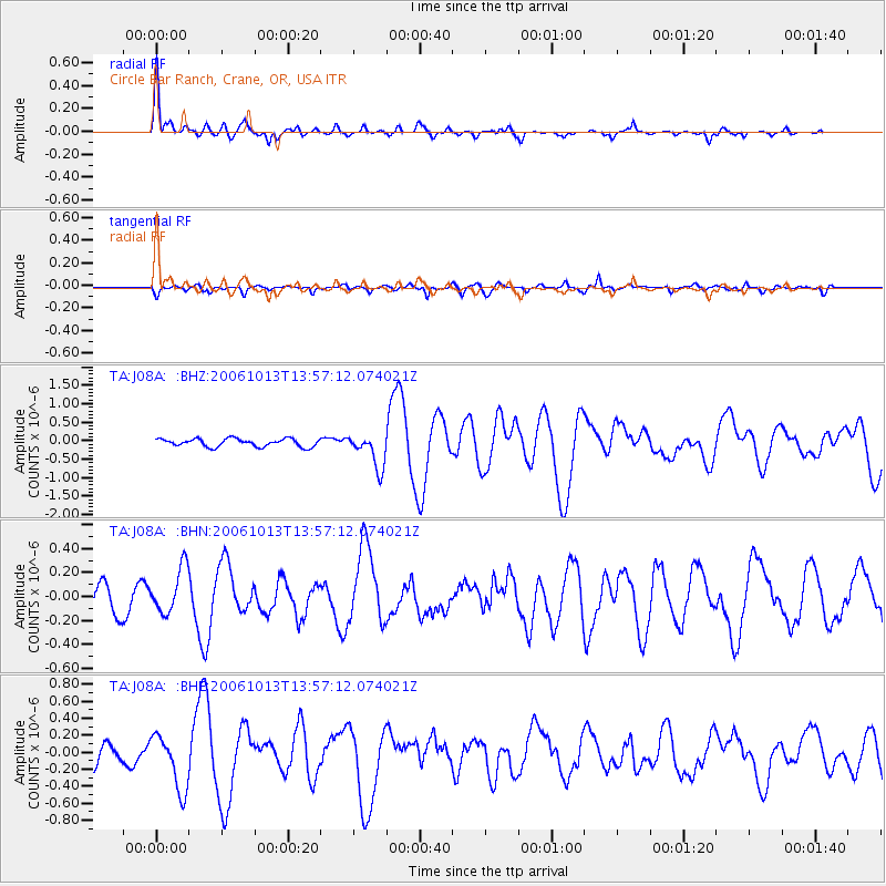
J08A Circle Bar Ranch, Crane, OR, USA - Earthquake Result Viewer

| Earthquake location: |
Kuril Islands |
| Earthquake latitude/longitude: |
46.3/153.3 |
| Earthquake time(UTC): |
2006/10/13 (286) 13:47:39 GMT |
| Earthquake Depth: |
8.0 km |
| Earthquake Magnitude: |
5.5 MB, 5.8 MS, 6.3 MW, 5.8 MW |
| Earthquake Catalog/Contributor: |
WHDF/NEIC |
|
| Network: |
TA USArray Transportable Network (new EarthScope stations) |
| Station: |
J08A Circle Bar Ranch, Crane, OR, USA |
| Lat/Lon: |
43.36 N/118.47 W |
| Elevation: |
1229 m |
|
| Distance: |
59.5 deg |
| Az: |
57.826 deg |
| Baz: |
306.364 deg |
| Ray Param: |
0.06217632 |
| Estimated Moho Depth: |
30.0 km |
| Estimated Crust Vp/Vs: |
1.85 |
| Assumed Crust Vp: |
6.279 km/s |
| Estimated Crust Vs: |
3.403 km/s |
| Estimated Crust Poisson's Ratio: |
0.29 |
|
| Radial Match: |
81.55938 % |
| Radial Bump: |
388 |
| Transverse Match: |
69.88232 % |
| Transverse Bump: |
400 |
| SOD ConfigId: |
2665 |
| Insert Time: |
2010-03-06 11:56:57.406 +0000 |
| GWidth: |
2.5 |
| Max Bumps: |
400 |
| Tol: |
0.001 |
|
Signal To Noise
| Channel | StoN | STA | LTA |
| TA:J08A: :BHN:20061013T13:57:12.074021Z | 1.6797029 | 1.8934414E-7 | 1.1272478E-7 |
| TA:J08A: :BHE:20061013T13:57:12.074021Z | 3.7492735 | 3.2410998E-7 | 8.644607E-8 |
| TA:J08A: :BHZ:20061013T13:57:12.074021Z | 4.3389072 | 4.6420553E-7 | 1.0698674E-7 |
| Arrivals |
| Ps | 4.2 SECOND |
| PpPs | 13 SECOND |
| PsPs/PpSs | 17 SECOND |


