You are here: Home > Network List > TA - USArray Transportable Network (new EarthScope stations) Stations List
> Station H31M Peel River, Yukon, CAN > Earthquake Result Viewer
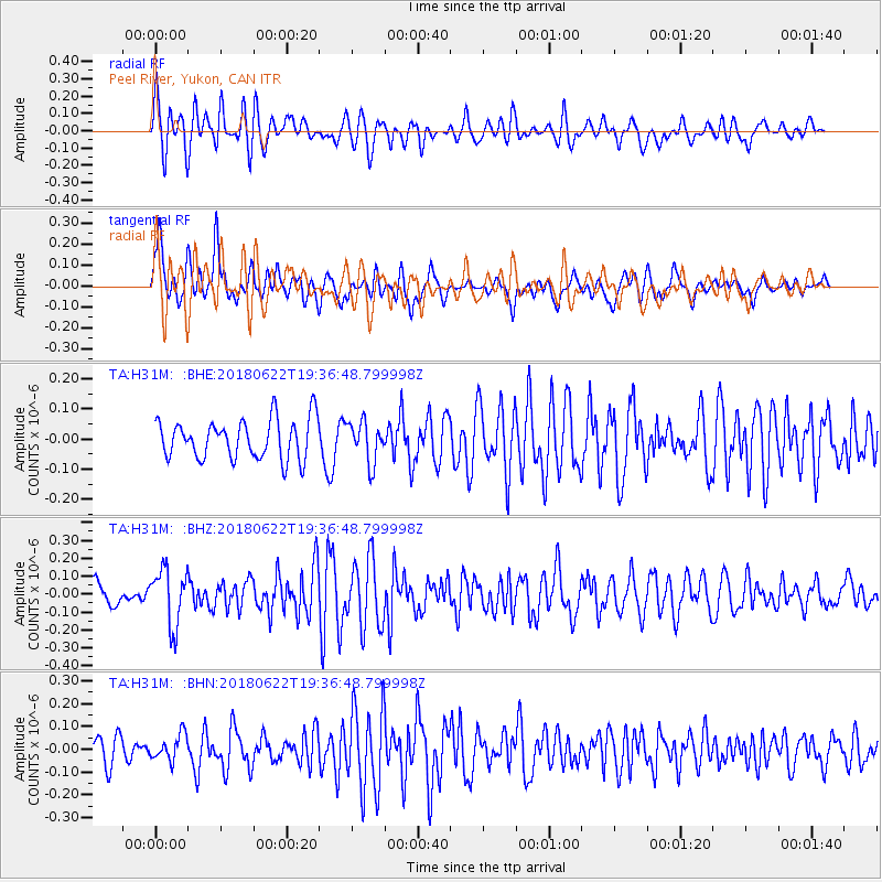
H31M Peel River, Yukon, CAN - Earthquake Result Viewer
*The percent match for this event was below the threshold and hence no stack was calculated.
| Earthquake location: |
Solomon Islands |
| Earthquake latitude/longitude: |
-10.0/161.7 |
| Earthquake time(UTC): |
2018/06/22 (173) 19:24:30 GMT |
| Earthquake Depth: |
43 km |
| Earthquake Magnitude: |
5.4 Mww |
| Earthquake Catalog/Contributor: |
NEIC PDE/us |
|
| Network: |
TA USArray Transportable Network (new EarthScope stations) |
| Station: |
H31M Peel River, Yukon, CAN |
| Lat/Lon: |
65.81 N/134.34 W |
| Elevation: |
642 m |
|
| Distance: |
88.8 deg |
| Az: |
21.748 deg |
| Baz: |
242.31 deg |
| Ray Param: |
$rayparam |
*The percent match for this event was below the threshold and hence was not used in the summary stack. |
|
| Radial Match: |
65.89438 % |
| Radial Bump: |
400 |
| Transverse Match: |
65.154465 % |
| Transverse Bump: |
400 |
| SOD ConfigId: |
13570011 |
| Insert Time: |
2019-04-30 10:43:02.783 +0000 |
| GWidth: |
2.5 |
| Max Bumps: |
400 |
| Tol: |
0.001 |
|
Signal To Noise
| Channel | StoN | STA | LTA |
| TA:H31M: :BHZ:20180622T19:36:48.799998Z | 2.7819314 | 1.5837627E-7 | 5.693033E-8 |
| TA:H31M: :BHN:20180622T19:36:48.799998Z | 1.2712519 | 5.672977E-8 | 4.462512E-8 |
| TA:H31M: :BHE:20180622T19:36:48.799998Z | 1.0321091 | 6.745496E-8 | 6.5356424E-8 |
| Arrivals |
| Ps | |
| PpPs | |
| PsPs/PpSs | |


