You are here: Home > Network List > IU - Global Seismograph Network (GSN - IRIS/USGS) Stations List
> Station FURI Mt. Furi, Ethiopia > Earthquake Result Viewer
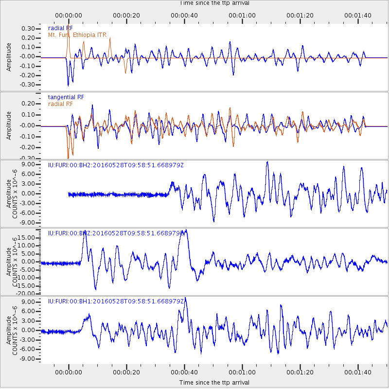
FURI Mt. Furi, Ethiopia - Earthquake Result Viewer
*The percent match for this event was below the threshold and hence no stack was calculated.
| Earthquake location: |
South Sandwich Islands Region |
| Earthquake latitude/longitude: |
-56.2/-26.9 |
| Earthquake time(UTC): |
2016/05/28 (149) 09:46:59 GMT |
| Earthquake Depth: |
73 km |
| Earthquake Magnitude: |
7.2 MWW, 7.3 MI |
| Earthquake Catalog/Contributor: |
NEIC PDE/NEIC COMCAT |
|
| Network: |
IU Global Seismograph Network (GSN - IRIS/USGS) |
| Station: |
FURI Mt. Furi, Ethiopia |
| Lat/Lon: |
8.90 N/38.68 E |
| Elevation: |
2570 m |
|
| Distance: |
84.2 deg |
| Az: |
64.729 deg |
| Baz: |
210.758 deg |
| Ray Param: |
$rayparam |
*The percent match for this event was below the threshold and hence was not used in the summary stack. |
|
| Radial Match: |
90.82838 % |
| Radial Bump: |
400 |
| Transverse Match: |
90.56896 % |
| Transverse Bump: |
400 |
| SOD ConfigId: |
1475611 |
| Insert Time: |
2016-06-11 09:52:15.525 +0000 |
| GWidth: |
2.5 |
| Max Bumps: |
400 |
| Tol: |
0.001 |
|
Signal To Noise
| Channel | StoN | STA | LTA |
| IU:FURI:00:BHZ:20160528T09:58:51.668979Z | 3.8799994 | 2.000952E-6 | 5.1570936E-7 |
| IU:FURI:00:BH1:20160528T09:58:51.668979Z | 1.601481 | 4.9646354E-7 | 3.1000275E-7 |
| IU:FURI:00:BH2:20160528T09:58:51.668979Z | 1.1877197 | 3.7745951E-7 | 3.1780183E-7 |
| Arrivals |
| Ps | |
| PpPs | |
| PsPs/PpSs | |


