You are here: Home > Network List > IU - Global Seismograph Network (GSN - IRIS/USGS) Stations List
> Station PAYG Puerto Ayora, Galapagos Islands > Earthquake Result Viewer
PAYG Puerto Ayora, Galapagos Islands - Earthquake Result Viewer

| Earthquake location: |
South Sandwich Islands Region |
| Earthquake latitude/longitude: |
-56.2/-26.9 |
| Earthquake time(UTC): |
2016/05/28 (149) 09:46:59 GMT |
| Earthquake Depth: |
73 km |
| Earthquake Magnitude: |
7.2 MWW, 7.3 MI |
| Earthquake Catalog/Contributor: |
NEIC PDE/NEIC COMCAT |
|
| Network: |
IU Global Seismograph Network (GSN - IRIS/USGS) |
| Station: |
PAYG Puerto Ayora, Galapagos Islands |
| Lat/Lon: |
0.67 S/90.29 W |
| Elevation: |
270 m |
|
| Distance: |
74.9 deg |
| Az: |
292.2 deg |
| Baz: |
148.839 deg |
| Ray Param: |
0.05184801 |
| Estimated Moho Depth: |
64.75 km |
| Estimated Crust Vp/Vs: |
1.89 |
| Assumed Crust Vp: |
4.802 km/s |
| Estimated Crust Vs: |
2.537 km/s |
| Estimated Crust Poisson's Ratio: |
0.31 |
|
| Radial Match: |
93.142654 % |
| Radial Bump: |
400 |
| Transverse Match: |
78.052376 % |
| Transverse Bump: |
400 |
| SOD ConfigId: |
1475611 |
| Insert Time: |
2016-06-11 09:52:46.712 +0000 |
| GWidth: |
2.5 |
| Max Bumps: |
400 |
| Tol: |
0.001 |
|
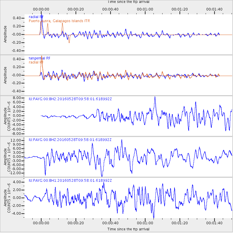
Signal To Noise
| Channel | StoN | STA | LTA |
| IU:PAYG:00:BHZ:20160528T09:58:01.618992Z | 9.126621 | 4.103642E-6 | 4.4963426E-7 |
| IU:PAYG:00:BH1:20160528T09:58:01.618992Z | 1.6892141 | 9.322428E-7 | 5.518796E-7 |
| IU:PAYG:00:BH2:20160528T09:58:01.618992Z | 5.0151668 | 1.6025928E-6 | 3.1954923E-7 |
| Arrivals |
| Ps | 12 SECOND |
| PpPs | 38 SECOND |
| PsPs/PpSs | 51 SECOND |


