You are here: Home > Network List > PF - Volcanologic Network of Piton de Fournaise-OVPF Stations List
> Station BON Bory Nord > Earthquake Result Viewer
BON Bory Nord - Earthquake Result Viewer
| Earthquake location: |
South Sandwich Islands Region |
| Earthquake latitude/longitude: |
-56.2/-26.9 |
| Earthquake time(UTC): |
2016/05/28 (149) 09:46:59 GMT |
| Earthquake Depth: |
73 km |
| Earthquake Magnitude: |
7.2 MWW, 7.3 MI |
| Earthquake Catalog/Contributor: |
NEIC PDE/NEIC COMCAT |
|
| Network: |
PF Volcanologic Network of Piton de Fournaise-OVPF |
| Station: |
BON Bory Nord |
| Lat/Lon: |
21.24 S/55.71 E |
| Elevation: |
2552 m |
|
| Distance: |
68.5 deg |
| Az: |
96.27 deg |
| Baz: |
216.544 deg |
| Ray Param: |
0.056065746 |
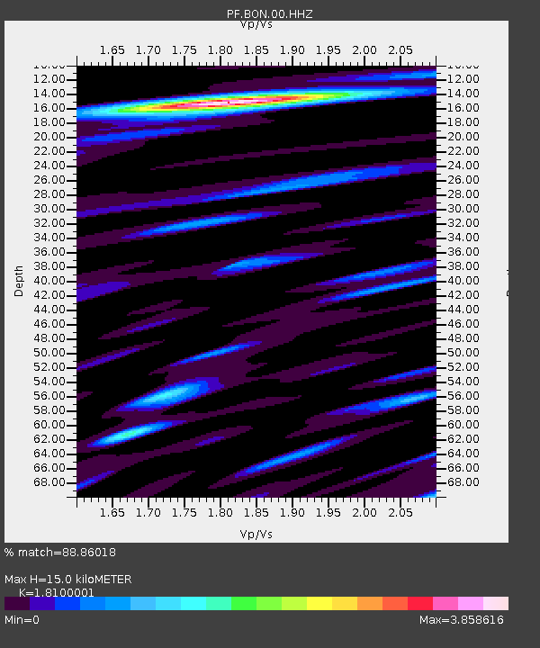
| Estimated Moho Depth: |
15.0 km |
| Estimated Crust Vp/Vs: |
1.81 |
| Assumed Crust Vp: |
4.73 km/s |
| Estimated Crust Vs: |
2.613 km/s |
| Estimated Crust Poisson's Ratio: |
0.28 |
|
| Radial Match: |
88.86018 % |
| Radial Bump: |
400 |
| Transverse Match: |
83.53839 % |
| Transverse Bump: |
400 |
| SOD ConfigId: |
1475611 |
| Insert Time: |
2016-06-11 09:54:01.555 +0000 |
| GWidth: |
2.5 |
| Max Bumps: |
400 |
| Tol: |
0.001 |
|
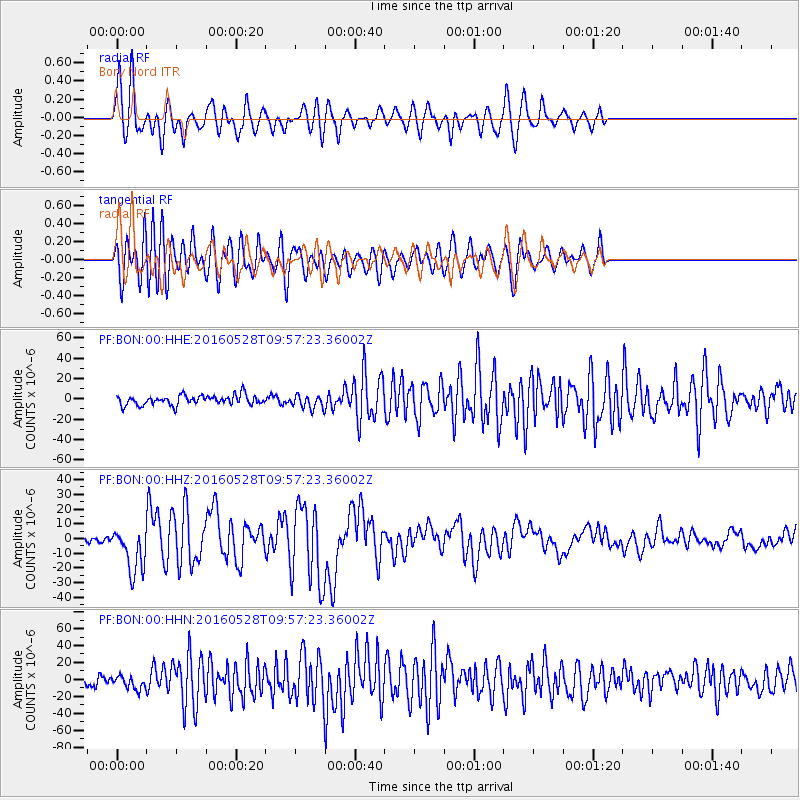
Signal To Noise
| Channel | StoN | STA | LTA |
| PF:BON:00:HHZ:20160528T09:57:23.36002Z | 9.050931 | 1.554269E-5 | 1.7172475E-6 |
| PF:BON:00:HHN:20160528T09:57:23.36002Z | 1.3878224 | 8.157602E-6 | 5.877987E-6 |
| PF:BON:00:HHE:20160528T09:57:23.36002Z | 1.3717378 | 6.6323087E-6 | 4.834968E-6 |
| Arrivals |
| Ps | 2.6 SECOND |
| PpPs | 8.7 SECOND |
| PsPs/PpSs | 11 SECOND |


