You are here: Home > Network List > PF - Volcanologic Network of Piton de Fournaise-OVPF Stations List
> Station FOR Station Sismologique de Chateau Fort > Earthquake Result Viewer
FOR Station Sismologique de Chateau Fort - Earthquake Result Viewer
| Earthquake location: |
South Sandwich Islands Region |
| Earthquake latitude/longitude: |
-56.2/-26.9 |
| Earthquake time(UTC): |
2016/05/28 (149) 09:46:59 GMT |
| Earthquake Depth: |
73 km |
| Earthquake Magnitude: |
7.2 MWW, 7.3 MI |
| Earthquake Catalog/Contributor: |
NEIC PDE/NEIC COMCAT |
|
| Network: |
PF Volcanologic Network of Piton de Fournaise-OVPF |
| Station: |
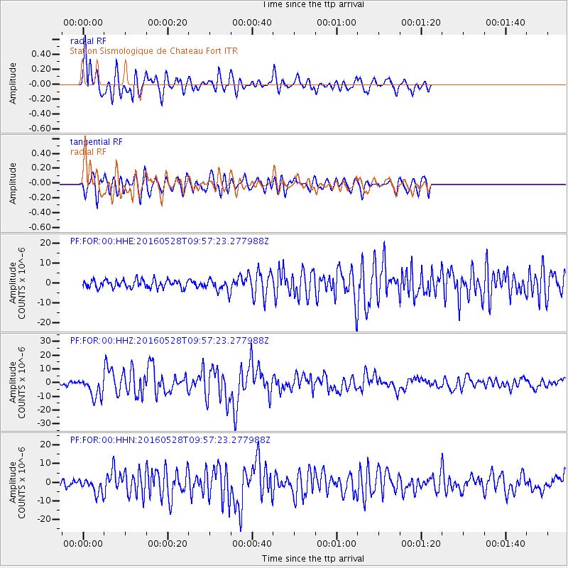
FOR Station Sismologique de Chateau Fort |
| Lat/Lon: |
21.26 S/55.72 E |
| Elevation: |
2049 m |
|
| Distance: |
68.5 deg |
| Az: |
96.292 deg |
| Baz: |
216.549 deg |
| Ray Param: |
0.056073852 |
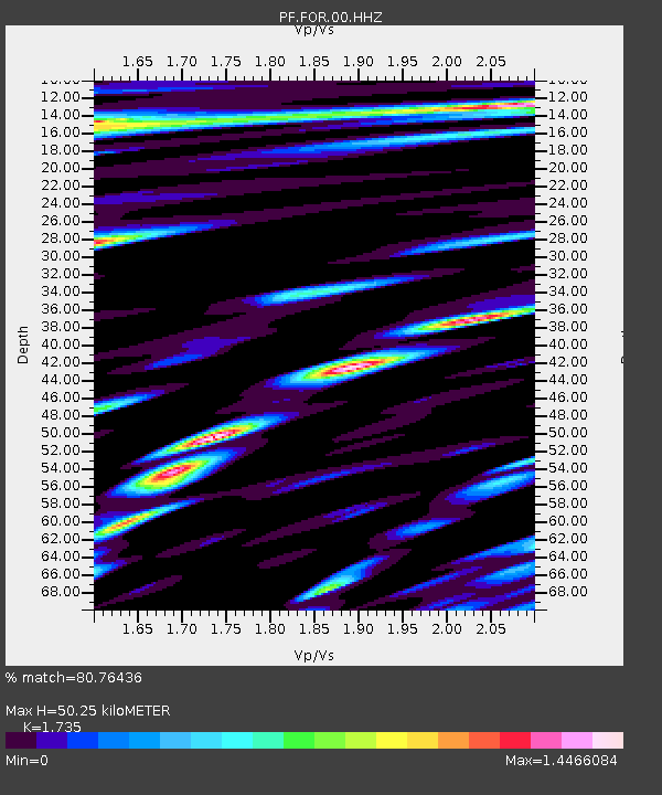
| Estimated Moho Depth: |
50.25 km |
| Estimated Crust Vp/Vs: |
1.74 |
| Assumed Crust Vp: |
4.73 km/s |
| Estimated Crust Vs: |
2.726 km/s |
| Estimated Crust Poisson's Ratio: |
0.25 |
|
| Radial Match: |
80.76436 % |
| Radial Bump: |
400 |
| Transverse Match: |
72.46024 % |
| Transverse Bump: |
400 |
| SOD ConfigId: |
1475611 |
| Insert Time: |
2016-06-11 09:54:23.316 +0000 |
| GWidth: |
2.5 |
| Max Bumps: |
400 |
| Tol: |
0.001 |
|
Signal To Noise
| Channel | StoN | STA | LTA |
| PF:FOR:00:HHZ:20160528T09:57:23.277988Z | 6.545939 | 7.6167094E-6 | 1.1635778E-6 |
| PF:FOR:00:HHN:20160528T09:57:23.277988Z | 2.3514833 | 4.054173E-6 | 1.7240919E-6 |
| PF:FOR:00:HHE:20160528T09:57:23.277988Z | 1.6382402 | 3.2435594E-6 | 1.9799045E-6 |
| Arrivals |
| Ps | 8.0 SECOND |
| PpPs | 28 SECOND |
| PsPs/PpSs | 36 SECOND |


