You are here: Home > Network List > TA - USArray Transportable Network (new EarthScope stations) Stations List
> Station B18K Kokolik River, AK, USA > Earthquake Result Viewer
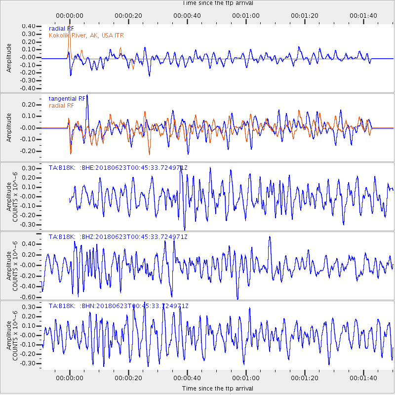
B18K Kokolik River, AK, USA - Earthquake Result Viewer
*The percent match for this event was below the threshold and hence no stack was calculated.
| Earthquake location: |
Solomon Islands |
| Earthquake latitude/longitude: |
-10.3/161.1 |
| Earthquake time(UTC): |
2018/06/23 (174) 00:33:39 GMT |
| Earthquake Depth: |
23 km |
| Earthquake Magnitude: |
5.5 Mww |
| Earthquake Catalog/Contributor: |
NEIC PDE/us |
|
| Network: |
TA USArray Transportable Network (new EarthScope stations) |
| Station: |
B18K Kokolik River, AK, USA |
| Lat/Lon: |
69.36 N/161.80 W |
| Elevation: |
222 m |
|
| Distance: |
83.5 deg |
| Az: |
12.422 deg |
| Baz: |
216.67 deg |
| Ray Param: |
$rayparam |
*The percent match for this event was below the threshold and hence was not used in the summary stack. |
|
| Radial Match: |
40.179073 % |
| Radial Bump: |
400 |
| Transverse Match: |
60.182636 % |
| Transverse Bump: |
400 |
| SOD ConfigId: |
13570011 |
| Insert Time: |
2019-04-30 10:49:40.271 +0000 |
| GWidth: |
2.5 |
| Max Bumps: |
400 |
| Tol: |
0.001 |
|
Signal To Noise
| Channel | StoN | STA | LTA |
| TA:B18K: :BHZ:20180623T00:45:33.724971Z | 2.1547995 | 3.0295192E-7 | 1.4059401E-7 |
| TA:B18K: :BHN:20180623T00:45:33.724971Z | 0.76009196 | 8.2335625E-8 | 1.0832324E-7 |
| TA:B18K: :BHE:20180623T00:45:33.724971Z | 0.99857324 | 9.569318E-8 | 9.582991E-8 |
| Arrivals |
| Ps | |
| PpPs | |
| PsPs/PpSs | |


