You are here: Home > Network List > PF - Volcanologic Network of Piton de Fournaise-OVPF Stations List
> Station GPN Grandes Pentes Nord > Earthquake Result Viewer
GPN Grandes Pentes Nord - Earthquake Result Viewer
| Earthquake location: |
South Sandwich Islands Region |
| Earthquake latitude/longitude: |
-56.2/-26.9 |
| Earthquake time(UTC): |
2016/05/28 (149) 09:46:59 GMT |
| Earthquake Depth: |
73 km |
| Earthquake Magnitude: |
7.2 MWW, 7.3 MI |
| Earthquake Catalog/Contributor: |
NEIC PDE/NEIC COMCAT |
|
| Network: |
PF Volcanologic Network of Piton de Fournaise-OVPF |
| Station: |
GPN Grandes Pentes Nord |
| Lat/Lon: |
21.24 S/55.75 E |
| Elevation: |
1413 m |
|
| Distance: |
68.6 deg |
| Az: |
96.305 deg |
| Baz: |
216.542 deg |
| Ray Param: |
0.056050126 |
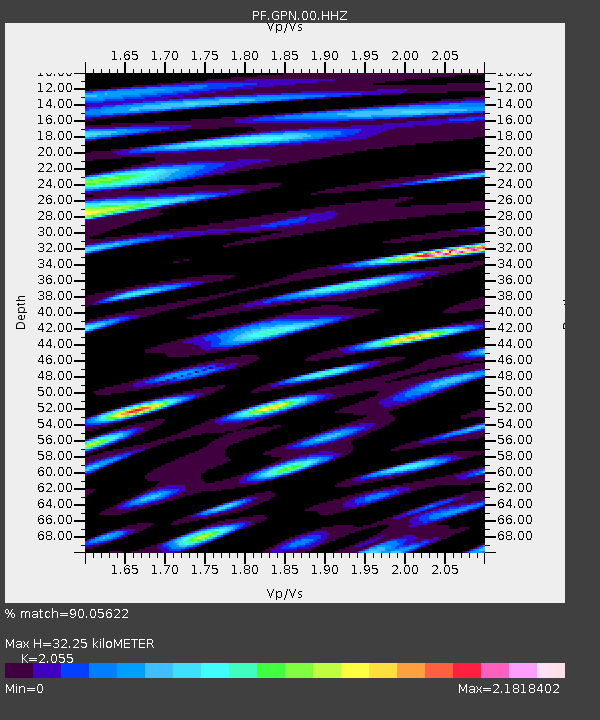
| Estimated Moho Depth: |
32.25 km |
| Estimated Crust Vp/Vs: |
2.06 |
| Assumed Crust Vp: |
4.73 km/s |
| Estimated Crust Vs: |
2.302 km/s |
| Estimated Crust Poisson's Ratio: |
0.34 |
|
| Radial Match: |
90.05622 % |
| Radial Bump: |
400 |
| Transverse Match: |
86.39863 % |
| Transverse Bump: |
400 |
| SOD ConfigId: |
1475611 |
| Insert Time: |
2016-06-11 09:54:31.437 +0000 |
| GWidth: |
2.5 |
| Max Bumps: |
400 |
| Tol: |
0.001 |
|
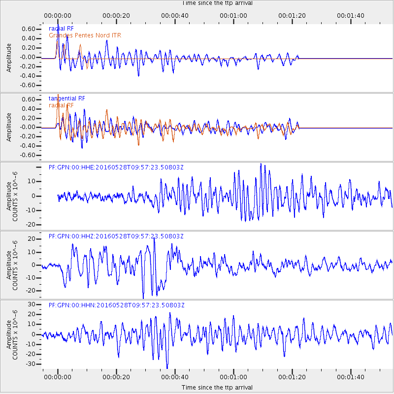
Signal To Noise
| Channel | StoN | STA | LTA |
| PF:GPN:00:HHZ:20160528T09:57:23.50803Z | 6.1300335 | 7.4654527E-6 | 1.2178486E-6 |
| PF:GPN:00:HHN:20160528T09:57:23.50803Z | 1.700723 | 2.607456E-6 | 1.5331457E-6 |
| PF:GPN:00:HHE:20160528T09:57:23.50803Z | 2.4554727 | 4.2810602E-6 | 1.743477E-6 |
| Arrivals |
| Ps | 7.3 SECOND |
| PpPs | 20 SECOND |
| PsPs/PpSs | 28 SECOND |


