You are here: Home > Network List > TA - USArray Transportable Network (new EarthScope stations) Stations List
> Station D22K Ayikyak River, AK, USA > Earthquake Result Viewer
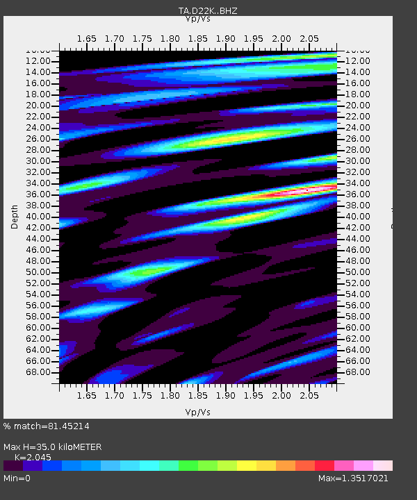
D22K Ayikyak River, AK, USA - Earthquake Result Viewer
| Earthquake location: |
Solomon Islands |
| Earthquake latitude/longitude: |
-10.3/161.1 |
| Earthquake time(UTC): |
2018/06/23 (174) 00:33:39 GMT |
| Earthquake Depth: |
23 km |
| Earthquake Magnitude: |
5.5 Mww |
| Earthquake Catalog/Contributor: |
NEIC PDE/us |
|
| Network: |
TA USArray Transportable Network (new EarthScope stations) |
| Station: |
D22K Ayikyak River, AK, USA |
| Lat/Lon: |
68.88 N/152.68 W |
| Elevation: |
532 m |
|
| Distance: |
85.3 deg |
| Az: |
15.217 deg |
| Baz: |
225.458 deg |
| Ray Param: |
0.04483491 |
| Estimated Moho Depth: |
35.0 km |
| Estimated Crust Vp/Vs: |
2.05 |
| Assumed Crust Vp: |
6.221 km/s |
| Estimated Crust Vs: |
3.042 km/s |
| Estimated Crust Poisson's Ratio: |
0.34 |
|
| Radial Match: |
81.45214 % |
| Radial Bump: |
400 |
| Transverse Match: |
71.029495 % |
| Transverse Bump: |
400 |
| SOD ConfigId: |
13570011 |
| Insert Time: |
2019-04-30 10:49:54.386 +0000 |
| GWidth: |
2.5 |
| Max Bumps: |
400 |
| Tol: |
0.001 |
|

Signal To Noise
| Channel | StoN | STA | LTA |
| TA:D22K: :BHZ:20180623T00:45:42.700007Z | 2.6096826 | 3.2283367E-7 | 1.2370612E-7 |
| TA:D22K: :BHN:20180623T00:45:42.700007Z | 2.3375766 | 9.642478E-8 | 4.1249887E-8 |
| TA:D22K: :BHE:20180623T00:45:42.700007Z | 2.2080164 | 9.972474E-8 | 4.5164857E-8 |
| Arrivals |
| Ps | 6.0 SECOND |
| PpPs | 17 SECOND |
| PsPs/PpSs | 23 SECOND |


