You are here: Home > Network List > PF - Volcanologic Network of Piton de Fournaise-OVPF Stations List
> Station HDL Station Sismologique de Hubert Delisle > Earthquake Result Viewer
HDL Station Sismologique de Hubert Delisle - Earthquake Result Viewer
| Earthquake location: |
South Sandwich Islands Region |
| Earthquake latitude/longitude: |
-56.2/-26.9 |
| Earthquake time(UTC): |
2016/05/28 (149) 09:46:59 GMT |
| Earthquake Depth: |
73 km |
| Earthquake Magnitude: |
7.2 MWW, 7.3 MI |
| Earthquake Catalog/Contributor: |
NEIC PDE/NEIC COMCAT |
|
| Network: |
PF Volcanologic Network of Piton de Fournaise-OVPF |
| Station: |
HDL Station Sismologique de Hubert Delisle |
| Lat/Lon: |
21.25 S/55.79 E |
| Elevation: |
242 m |
|
| Distance: |
68.6 deg |
| Az: |
96.343 deg |
| Baz: |
216.542 deg |
| Ray Param: |
0.056042023 |
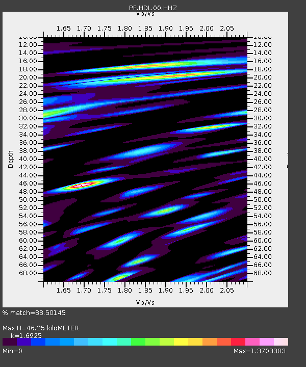
| Estimated Moho Depth: |
46.25 km |
| Estimated Crust Vp/Vs: |
1.69 |
| Assumed Crust Vp: |
4.73 km/s |
| Estimated Crust Vs: |
2.795 km/s |
| Estimated Crust Poisson's Ratio: |
0.23 |
|
| Radial Match: |
88.50145 % |
| Radial Bump: |
400 |
| Transverse Match: |
79.94613 % |
| Transverse Bump: |
400 |
| SOD ConfigId: |
1475611 |
| Insert Time: |
2016-06-11 09:54:42.838 +0000 |
| GWidth: |
2.5 |
| Max Bumps: |
400 |
| Tol: |
0.001 |
|
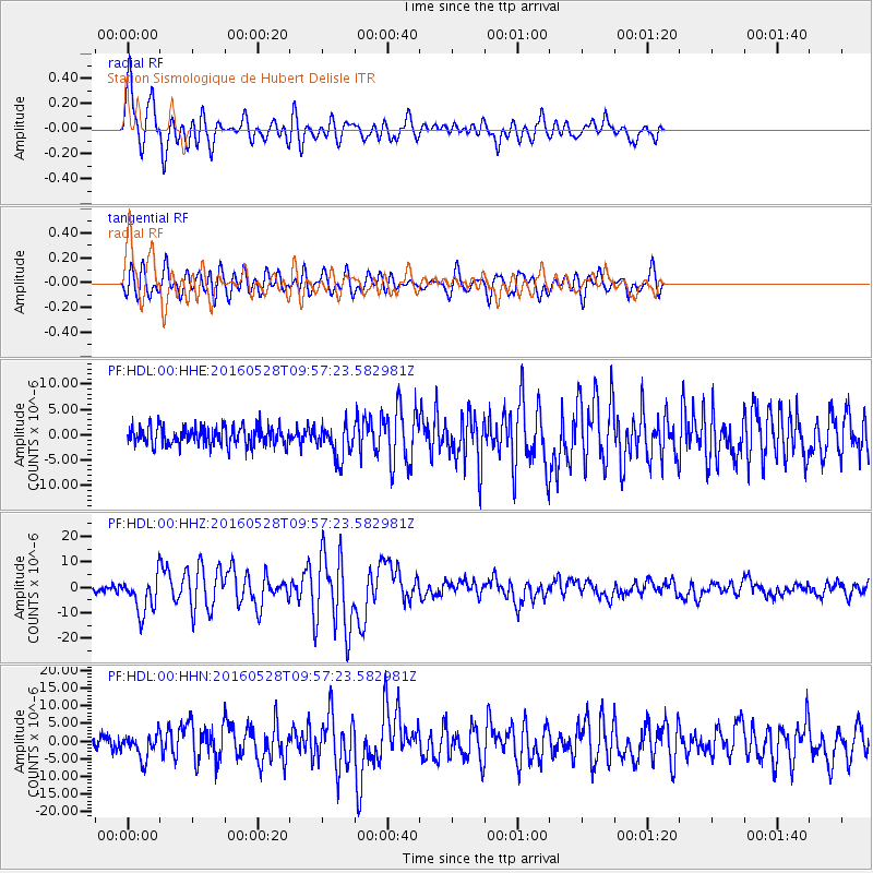
Signal To Noise
| Channel | StoN | STA | LTA |
| PF:HDL:00:HHZ:20160528T09:57:23.582981Z | 8.178762 | 7.1470063E-6 | 8.7384933E-7 |
| PF:HDL:00:HHN:20160528T09:57:23.582981Z | 1.81795 | 3.3528077E-6 | 1.8442793E-6 |
| PF:HDL:00:HHE:20160528T09:57:23.582981Z | 1.8290745 | 3.3141507E-6 | 1.8119276E-6 |
| Arrivals |
| Ps | 6.9 SECOND |
| PpPs | 26 SECOND |
| PsPs/PpSs | 33 SECOND |


