You are here: Home > Network List > CI - Caltech Regional Seismic Network Stations List
> Station ADO Adelanto Receiving Station, Victorville, CA, USA > Earthquake Result Viewer
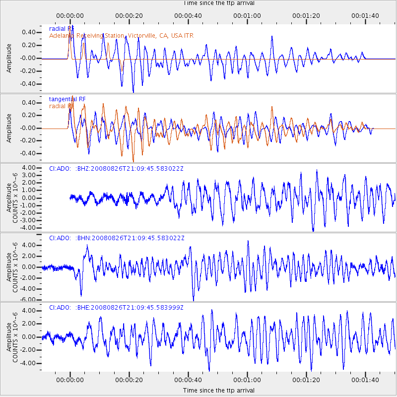
ADO Adelanto Receiving Station, Victorville, CA, USA - Earthquake Result Viewer
*The percent match for this event was below the threshold and hence no stack was calculated.
| Earthquake location: |
Peru-Brazil Border Region |
| Earthquake latitude/longitude: |
-7.6/-74.4 |
| Earthquake time(UTC): |
2008/08/26 (239) 21:00:36 GMT |
| Earthquake Depth: |
154 km |
| Earthquake Magnitude: |
6.0 MB, 6.4 MW, 6.4 MW |
| Earthquake Catalog/Contributor: |
WHDF/NEIC |
|
| Network: |
CI Caltech Regional Seismic Network |
| Station: |
ADO Adelanto Receiving Station, Victorville, CA, USA |
| Lat/Lon: |
34.55 N/117.43 W |
| Elevation: |
908 m |
|
| Distance: |
58.4 deg |
| Az: |
318.603 deg |
| Baz: |
127.427 deg |
| Ray Param: |
$rayparam |
*The percent match for this event was below the threshold and hence was not used in the summary stack. |
|
| Radial Match: |
79.97139 % |
| Radial Bump: |
400 |
| Transverse Match: |
71.49418 % |
| Transverse Bump: |
400 |
| SOD ConfigId: |
2504 |
| Insert Time: |
2010-02-26 02:01:39.317 +0000 |
| GWidth: |
2.5 |
| Max Bumps: |
400 |
| Tol: |
0.001 |
|
Signal To Noise
| Channel | StoN | STA | LTA |
| CI:ADO: :BHN:20080826T21:09:45.583022Z | 5.8589473 | 1.7803973E-6 | 3.0387665E-7 |
| CI:ADO: :BHE:20080826T21:09:45.583999Z | 1.6524322 | 6.6974786E-7 | 4.0531035E-7 |
| CI:ADO: :BHZ:20080826T21:09:45.583022Z | 1.7594823 | 8.17088E-7 | 4.6439118E-7 |
| Arrivals |
| Ps | |
| PpPs | |
| PsPs/PpSs | |


