You are here: Home > Network List > TA - USArray Transportable Network (new EarthScope stations) Stations List
> Station K27K Chicken, AK, USA > Earthquake Result Viewer
K27K Chicken, AK, USA - Earthquake Result Viewer
| Earthquake location: |
Solomon Islands |
| Earthquake latitude/longitude: |
-10.3/161.1 |
| Earthquake time(UTC): |
2018/06/23 (174) 00:33:39 GMT |
| Earthquake Depth: |
23 km |
| Earthquake Magnitude: |
5.5 Mww |
| Earthquake Catalog/Contributor: |
NEIC PDE/us |
|
| Network: |
TA USArray Transportable Network (new EarthScope stations) |
| Station: |
K27K Chicken, AK, USA |
| Lat/Lon: |
64.03 N/142.08 W |
| Elevation: |
389 m |
|
| Distance: |
85.5 deg |
| Az: |
21.69 deg |
| Baz: |
235.702 deg |
| Ray Param: |
0.044686392 |
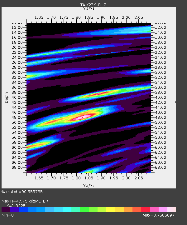
| Estimated Moho Depth: |
47.75 km |
| Estimated Crust Vp/Vs: |
1.82 |
| Assumed Crust Vp: |
6.566 km/s |
| Estimated Crust Vs: |
3.603 km/s |
| Estimated Crust Poisson's Ratio: |
0.28 |
|
| Radial Match: |
90.959785 % |
| Radial Bump: |
345 |
| Transverse Match: |
74.97657 % |
| Transverse Bump: |
400 |
| SOD ConfigId: |
13570011 |
| Insert Time: |
2019-04-30 10:50:55.549 +0000 |
| GWidth: |
2.5 |
| Max Bumps: |
400 |
| Tol: |
0.001 |
|

Signal To Noise
| Channel | StoN | STA | LTA |
| TA:K27K: :BHZ:20180623T00:45:43.749995Z | 7.483395 | 4.1869114E-7 | 5.5949357E-8 |
| TA:K27K: :BHN:20180623T00:45:43.749995Z | 2.8300133 | 1.0518522E-7 | 3.7167748E-8 |
| TA:K27K: :BHE:20180623T00:45:43.749995Z | 4.4411154 | 1.18898704E-7 | 2.6772263E-8 |
| Arrivals |
| Ps | 6.1 SECOND |
| PpPs | 20 SECOND |
| PsPs/PpSs | 26 SECOND |


