You are here: Home > Network List > TA - USArray Transportable Network (new EarthScope stations) Stations List
> Station L20K Farewell, AK, USA > Earthquake Result Viewer
L20K Farewell, AK, USA - Earthquake Result Viewer

| Earthquake location: |
Solomon Islands |
| Earthquake latitude/longitude: |
-10.3/161.1 |
| Earthquake time(UTC): |
2018/06/23 (174) 00:33:39 GMT |
| Earthquake Depth: |
23 km |
| Earthquake Magnitude: |
5.5 Mww |
| Earthquake Catalog/Contributor: |
NEIC PDE/us |
|
| Network: |
TA USArray Transportable Network (new EarthScope stations) |
| Station: |
L20K Farewell, AK, USA |
| Lat/Lon: |
62.48 N/153.88 W |
| Elevation: |
673 m |
|
| Distance: |
80.4 deg |
| Az: |
19.458 deg |
| Baz: |
224.893 deg |
| Ray Param: |
0.04826409 |
| Estimated Moho Depth: |
23.0 km |
| Estimated Crust Vp/Vs: |
1.60 |
| Assumed Crust Vp: |
6.566 km/s |
| Estimated Crust Vs: |
4.104 km/s |
| Estimated Crust Poisson's Ratio: |
0.18 |
|
| Radial Match: |
85.4095 % |
| Radial Bump: |
400 |
| Transverse Match: |
80.45075 % |
| Transverse Bump: |
400 |
| SOD ConfigId: |
13570011 |
| Insert Time: |
2019-04-30 10:51:02.383 +0000 |
| GWidth: |
2.5 |
| Max Bumps: |
400 |
| Tol: |
0.001 |
|
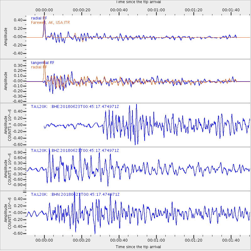
Signal To Noise
| Channel | StoN | STA | LTA |
| TA:L20K: :BHZ:20180623T00:45:17.474971Z | 6.1417947 | 4.5402174E-7 | 7.39233E-8 |
| TA:L20K: :BHN:20180623T00:45:17.474971Z | 2.4500444 | 1.17966984E-7 | 4.8148916E-8 |
| TA:L20K: :BHE:20180623T00:45:17.474971Z | 5.162819 | 1.9079941E-7 | 3.6956443E-8 |
| Arrivals |
| Ps | 2.2 SECOND |
| PpPs | 8.8 SECOND |
| PsPs/PpSs | 11 SECOND |


