You are here: Home > Network List > TA - USArray Transportable Network (new EarthScope stations) Stations List
> Station O17K Koliganek, Bristol Bay, AK, USA > Earthquake Result Viewer
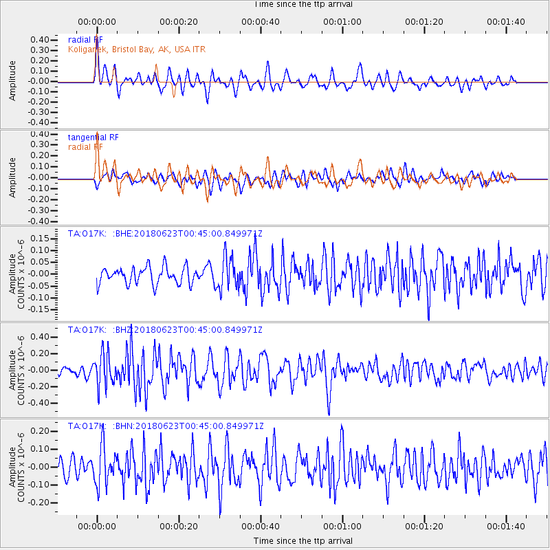
O17K Koliganek, Bristol Bay, AK, USA - Earthquake Result Viewer
*The percent match for this event was below the threshold and hence no stack was calculated.
| Earthquake location: |
Solomon Islands |
| Earthquake latitude/longitude: |
-10.3/161.1 |
| Earthquake time(UTC): |
2018/06/23 (174) 00:33:39 GMT |
| Earthquake Depth: |
23 km |
| Earthquake Magnitude: |
5.5 Mww |
| Earthquake Catalog/Contributor: |
NEIC PDE/us |
|
| Network: |
TA USArray Transportable Network (new EarthScope stations) |
| Station: |
O17K Koliganek, Bristol Bay, AK, USA |
| Lat/Lon: |
59.77 N/157.09 W |
| Elevation: |
156 m |
|
| Distance: |
77.4 deg |
| Az: |
20.212 deg |
| Baz: |
222.227 deg |
| Ray Param: |
$rayparam |
*The percent match for this event was below the threshold and hence was not used in the summary stack. |
|
| Radial Match: |
66.11425 % |
| Radial Bump: |
400 |
| Transverse Match: |
57.553078 % |
| Transverse Bump: |
400 |
| SOD ConfigId: |
13570011 |
| Insert Time: |
2019-04-30 10:51:26.904 +0000 |
| GWidth: |
2.5 |
| Max Bumps: |
400 |
| Tol: |
0.001 |
|
Signal To Noise
| Channel | StoN | STA | LTA |
| TA:O17K: :BHZ:20180623T00:45:00.849971Z | 3.7732732 | 1.9226486E-7 | 5.0954398E-8 |
| TA:O17K: :BHN:20180623T00:45:00.849971Z | 2.0598576 | 1.09044976E-7 | 5.2938113E-8 |
| TA:O17K: :BHE:20180623T00:45:00.849971Z | 1.963246 | 6.8556254E-8 | 3.491985E-8 |
| Arrivals |
| Ps | |
| PpPs | |
| PsPs/PpSs | |


