You are here: Home > Network List > PF - Volcanologic Network of Piton de Fournaise-OVPF Stations List
> Station PRA Puys Ramond > Earthquake Result Viewer
PRA Puys Ramond - Earthquake Result Viewer
| Earthquake location: |
South Sandwich Islands Region |
| Earthquake latitude/longitude: |
-56.2/-26.9 |
| Earthquake time(UTC): |
2016/05/28 (149) 09:46:59 GMT |
| Earthquake Depth: |
73 km |
| Earthquake Magnitude: |
7.2 MWW, 7.3 MI |
| Earthquake Catalog/Contributor: |
NEIC PDE/NEIC COMCAT |
|
| Network: |
PF Volcanologic Network of Piton de Fournaise-OVPF |
| Station: |
PRA Puys Ramond |
| Lat/Lon: |
21.29 S/55.71 E |
| Elevation: |
2009 m |
|
| Distance: |
68.5 deg |
| Az: |
96.303 deg |
| Baz: |
216.557 deg |
| Ray Param: |
0.056093305 |
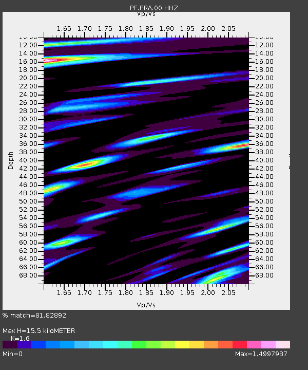
| Estimated Moho Depth: |
15.5 km |
| Estimated Crust Vp/Vs: |
1.60 |
| Assumed Crust Vp: |
4.73 km/s |
| Estimated Crust Vs: |
2.956 km/s |
| Estimated Crust Poisson's Ratio: |
0.18 |
|
| Radial Match: |
81.82892 % |
| Radial Bump: |
400 |
| Transverse Match: |
79.76424 % |
| Transverse Bump: |
400 |
| SOD ConfigId: |
1475611 |
| Insert Time: |
2016-06-11 09:55:45.593 +0000 |
| GWidth: |
2.5 |
| Max Bumps: |
400 |
| Tol: |
0.001 |
|
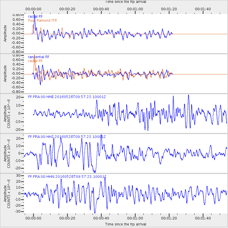
Signal To Noise
| Channel | StoN | STA | LTA |
| PF:PRA:00:HHZ:20160528T09:57:23.10001Z | 5.5453568 | 8.749706E-6 | 1.5778435E-6 |
| PF:PRA:00:HHN:20160528T09:57:23.10001Z | 2.3657823 | 5.262422E-6 | 2.2243898E-6 |
| PF:PRA:00:HHE:20160528T09:57:23.10001Z | 1.2450739 | 2.8272257E-6 | 2.2707293E-6 |
| Arrivals |
| Ps | 2.0 SECOND |
| PpPs | 8.3 SECOND |
| PsPs/PpSs | 10 SECOND |


