You are here: Home > Network List > UW - Pacific Northwest Regional Seismic Network Stations List
> Station HOOD Mt Hood Meadows, OR CREST BB SMO > Earthquake Result Viewer
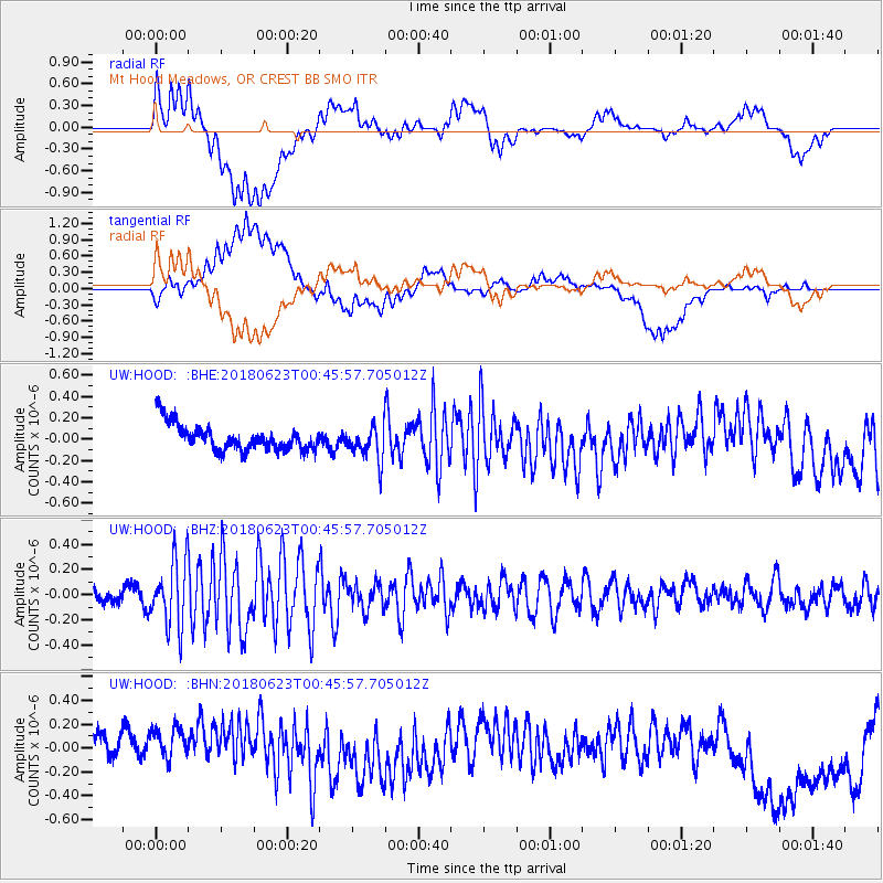
HOOD Mt Hood Meadows, OR CREST BB SMO - Earthquake Result Viewer
*The percent match for this event was below the threshold and hence no stack was calculated.
| Earthquake location: |
Solomon Islands |
| Earthquake latitude/longitude: |
-10.3/161.1 |
| Earthquake time(UTC): |
2018/06/23 (174) 00:33:39 GMT |
| Earthquake Depth: |
23 km |
| Earthquake Magnitude: |
5.5 Mww |
| Earthquake Catalog/Contributor: |
NEIC PDE/us |
|
| Network: |
UW Pacific Northwest Regional Seismic Network |
| Station: |
HOOD Mt Hood Meadows, OR CREST BB SMO |
| Lat/Lon: |
45.32 N/121.65 W |
| Elevation: |
1520 m |
|
| Distance: |
88.4 deg |
| Az: |
43.498 deg |
| Baz: |
253.784 deg |
| Ray Param: |
$rayparam |
*The percent match for this event was below the threshold and hence was not used in the summary stack. |
|
| Radial Match: |
59.027473 % |
| Radial Bump: |
400 |
| Transverse Match: |
46.06182 % |
| Transverse Bump: |
400 |
| SOD ConfigId: |
13570011 |
| Insert Time: |
2019-04-30 10:52:10.374 +0000 |
| GWidth: |
2.5 |
| Max Bumps: |
400 |
| Tol: |
0.001 |
|
Signal To Noise
| Channel | StoN | STA | LTA |
| UW:HOOD: :BHZ:20180623T00:45:57.705012Z | 4.531814 | 2.652085E-7 | 5.8521493E-8 |
| UW:HOOD: :BHN:20180623T00:45:57.705012Z | 1.215702 | 2.7703743E-7 | 2.2788268E-7 |
| UW:HOOD: :BHE:20180623T00:45:57.705012Z | 1.3080313 | 1.6473405E-7 | 1.2594045E-7 |
| Arrivals |
| Ps | |
| PpPs | |
| PsPs/PpSs | |


