You are here: Home > Network List > AV - Alaska Volcano Observatory Stations List
> Station SPCG Capps Glacier, Mount Spurr, Alaska > Earthquake Result Viewer
SPCG Capps Glacier, Mount Spurr, Alaska - Earthquake Result Viewer
| Earthquake location: |
Near Coast Of Venezuela |
| Earthquake latitude/longitude: |
10.8/-62.6 |
| Earthquake time(UTC): |
2018/06/23 (174) 01:54:42 GMT |
| Earthquake Depth: |
106 km |
| Earthquake Magnitude: |
5.1 Mww |
| Earthquake Catalog/Contributor: |
NEIC PDE/us |
|
| Network: |
AV Alaska Volcano Observatory |
| Station: |
SPCG Capps Glacier, Mount Spurr, Alaska |
| Lat/Lon: |
61.29 N/152.02 W |
| Elevation: |
1329 m |
|
| Distance: |
80.4 deg |
| Az: |
330.677 deg |
| Baz: |
85.317 deg |
| Ray Param: |
0.04809667 |
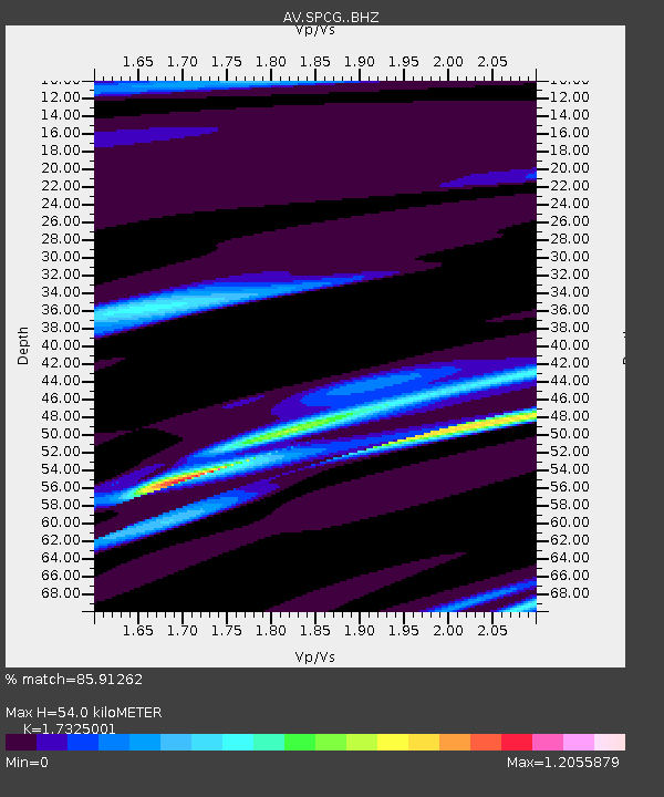
| Estimated Moho Depth: |
54.0 km |
| Estimated Crust Vp/Vs: |
1.73 |
| Assumed Crust Vp: |
6.566 km/s |
| Estimated Crust Vs: |
3.79 km/s |
| Estimated Crust Poisson's Ratio: |
0.25 |
|
| Radial Match: |
85.91262 % |
| Radial Bump: |
199 |
| Transverse Match: |
90.434845 % |
| Transverse Bump: |
219 |
| SOD ConfigId: |
13570011 |
| Insert Time: |
2019-04-30 10:55:29.355 +0000 |
| GWidth: |
2.5 |
| Max Bumps: |
400 |
| Tol: |
0.001 |
|

Signal To Noise
| Channel | StoN | STA | LTA |
| AV:SPCG: :BHZ:20180623T02:06:10.978997Z | 2.1225004 | 5.237256E-7 | 2.4674935E-7 |
| AV:SPCG: :BHN:20180623T02:06:10.978997Z | 0.4791939 | 4.370379E-7 | 9.1202725E-7 |
| AV:SPCG: :BHE:20180623T02:06:10.978997Z | 0.51903844 | 2.2850044E-7 | 4.4023798E-7 |
| Arrivals |
| Ps | 6.2 SECOND |
| PpPs | 22 SECOND |
| PsPs/PpSs | 28 SECOND |


