You are here: Home > Network List > TA - USArray Transportable Network (new EarthScope stations) Stations List
> Station M16A Huntsville, UT, USA > Earthquake Result Viewer
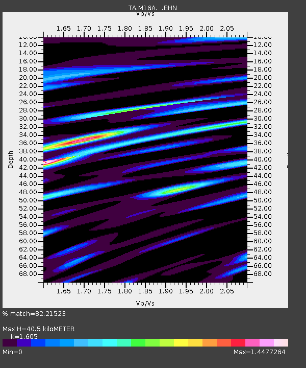
M16A Huntsville, UT, USA - Earthquake Result Viewer
| Earthquake location: |
Andreanof Islands, Aleutian Is. |
| Earthquake latitude/longitude: |
52.2/-178.7 |
| Earthquake time(UTC): |
2008/03/22 (082) 21:24:11 GMT |
| Earthquake Depth: |
132 km |
| Earthquake Magnitude: |
5.8 MB, 6.2 MW, 6.1 MW |
| Earthquake Catalog/Contributor: |
WHDF/NEIC |
|
| Network: |
TA USArray Transportable Network (new EarthScope stations) |
| Station: |
M16A Huntsville, UT, USA |
| Lat/Lon: |
41.31 N/111.63 W |
| Elevation: |
1872 m |
|
| Distance: |
45.7 deg |
| Az: |
75.928 deg |
| Baz: |
307.537 deg |
| Ray Param: |
0.07066562 |
| Estimated Moho Depth: |
40.5 km |
| Estimated Crust Vp/Vs: |
1.61 |
| Assumed Crust Vp: |
6.155 km/s |
| Estimated Crust Vs: |
3.835 km/s |
| Estimated Crust Poisson's Ratio: |
0.18 |
|
| Radial Match: |
82.21523 % |
| Radial Bump: |
400 |
| Transverse Match: |
69.5465 % |
| Transverse Bump: |
400 |
| SOD ConfigId: |
2564 |
| Insert Time: |
2010-03-06 12:00:50.458 +0000 |
| GWidth: |
2.5 |
| Max Bumps: |
400 |
| Tol: |
0.001 |
|

Signal To Noise
| Channel | StoN | STA | LTA |
| TA:M16A: :BHN:20080322T21:31:48.275005Z | 3.272961 | 5.1834445E-7 | 1.583717E-7 |
| TA:M16A: :BHE:20080322T21:31:48.275005Z | 8.599676 | 1.2134126E-6 | 1.410998E-7 |
| TA:M16A: :BHZ:20080322T21:31:48.275005Z | 20.423313 | 2.0178697E-6 | 9.8802275E-8 |
| Arrivals |
| Ps | 4.2 SECOND |
| PpPs | 16 SECOND |
| PsPs/PpSs | 20 SECOND |


