You are here: Home > Network List > CN - Canadian National Seismograph Network Stations List
> Station INK INUVIK, NT > Earthquake Result Viewer
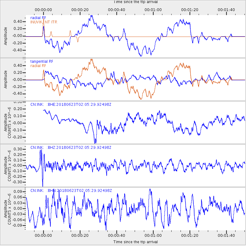
INK INUVIK, NT - Earthquake Result Viewer
*The percent match for this event was below the threshold and hence no stack was calculated.
| Earthquake location: |
Near Coast Of Venezuela |
| Earthquake latitude/longitude: |
10.8/-62.6 |
| Earthquake time(UTC): |
2018/06/23 (174) 01:54:42 GMT |
| Earthquake Depth: |
106 km |
| Earthquake Magnitude: |
5.1 Mww |
| Earthquake Catalog/Contributor: |
NEIC PDE/us |
|
| Network: |
CN Canadian National Seismograph Network |
| Station: |
INK INUVIK, NT |
| Lat/Lon: |
68.31 N/133.53 W |
| Elevation: |
44 m |
|
| Distance: |
73.0 deg |
| Az: |
338.451 deg |
| Baz: |
103.885 deg |
| Ray Param: |
$rayparam |
*The percent match for this event was below the threshold and hence was not used in the summary stack. |
|
| Radial Match: |
40.617626 % |
| Radial Bump: |
400 |
| Transverse Match: |
44.85934 % |
| Transverse Bump: |
400 |
| SOD ConfigId: |
13570011 |
| Insert Time: |
2019-04-30 10:56:59.493 +0000 |
| GWidth: |
2.5 |
| Max Bumps: |
400 |
| Tol: |
0.001 |
|
Signal To Noise
| Channel | StoN | STA | LTA |
| CN:INK: :BHZ:20180623T02:05:29.92498Z | 3.4781988 | 1.2530343E-7 | 3.602538E-8 |
| CN:INK: :BHN:20180623T02:05:29.92498Z | 1.4711515 | 6.1088315E-8 | 4.152415E-8 |
| CN:INK: :BHE:20180623T02:05:29.92498Z | 1.8223674 | 1.3218785E-7 | 7.253633E-8 |
| Arrivals |
| Ps | |
| PpPs | |
| PsPs/PpSs | |


