You are here: Home > Network List > TA - USArray Transportable Network (new EarthScope stations) Stations List
> Station M16A Huntsville, UT, USA > Earthquake Result Viewer
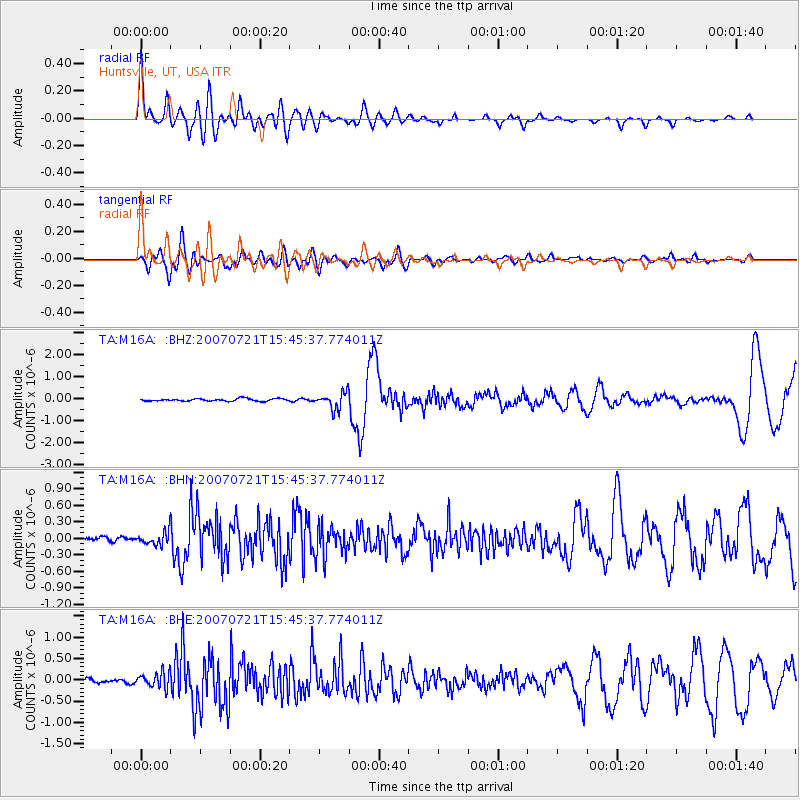
M16A Huntsville, UT, USA - Earthquake Result Viewer

| Earthquake location: |
Jujuy Province, Argentina |
| Earthquake latitude/longitude: |
-22.2/-65.8 |
| Earthquake time(UTC): |
2007/07/21 (202) 15:34:52 GMT |
| Earthquake Depth: |
290 km |
| Earthquake Magnitude: |
5.8 MB, 6.4 MW, 6.3 MW |
| Earthquake Catalog/Contributor: |
WHDF/NEIC |
|
| Network: |
TA USArray Transportable Network (new EarthScope stations) |
| Station: |
M16A Huntsville, UT, USA |
| Lat/Lon: |
41.31 N/111.63 W |
| Elevation: |
1872 m |
|
| Distance: |
76.1 deg |
| Az: |
326.167 deg |
| Baz: |
136.747 deg |
| Ray Param: |
0.05041511 |
| Estimated Moho Depth: |
23.5 km |
| Estimated Crust Vp/Vs: |
2.09 |
| Assumed Crust Vp: |
6.155 km/s |
| Estimated Crust Vs: |
2.941 km/s |
| Estimated Crust Poisson's Ratio: |
0.35 |
|
| Radial Match: |
92.04049 % |
| Radial Bump: |
400 |
| Transverse Match: |
80.679855 % |
| Transverse Bump: |
400 |
| SOD ConfigId: |
2564 |
| Insert Time: |
2010-03-06 12:01:54.475 +0000 |
| GWidth: |
2.5 |
| Max Bumps: |
400 |
| Tol: |
0.001 |
|
Signal To Noise
| Channel | StoN | STA | LTA |
| TA:M16A: :BHN:20070721T15:45:37.774011Z | 2.033728 | 1.1641991E-7 | 5.7244588E-8 |
| TA:M16A: :BHE:20070721T15:45:37.774011Z | 4.3308434 | 1.8202275E-7 | 4.20294E-8 |
| TA:M16A: :BHZ:20070721T15:45:37.774011Z | 6.808763 | 3.7461476E-7 | 5.5019505E-8 |
| Arrivals |
| Ps | 4.3 SECOND |
| PpPs | 12 SECOND |
| PsPs/PpSs | 16 SECOND |


