You are here: Home > Network List > TA - USArray Transportable Network (new EarthScope stations) Stations List
> Station F21K Alatna River, AK, USA > Earthquake Result Viewer
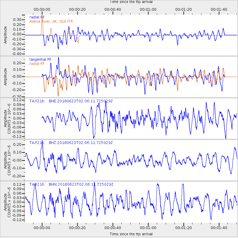
F21K Alatna River, AK, USA - Earthquake Result Viewer
*The percent match for this event was below the threshold and hence no stack was calculated.
| Earthquake location: |
Near Coast Of Venezuela |
| Earthquake latitude/longitude: |
10.8/-62.6 |
| Earthquake time(UTC): |
2018/06/23 (174) 01:54:42 GMT |
| Earthquake Depth: |
106 km |
| Earthquake Magnitude: |
5.1 Mww |
| Earthquake Catalog/Contributor: |
NEIC PDE/us |
|
| Network: |
TA USArray Transportable Network (new EarthScope stations) |
| Station: |
F21K Alatna River, AK, USA |
| Lat/Lon: |
67.22 N/153.48 W |
| Elevation: |
597 m |
|
| Distance: |
80.5 deg |
| Az: |
336.749 deg |
| Baz: |
85.011 deg |
| Ray Param: |
$rayparam |
*The percent match for this event was below the threshold and hence was not used in the summary stack. |
|
| Radial Match: |
53.005558 % |
| Radial Bump: |
400 |
| Transverse Match: |
71.82681 % |
| Transverse Bump: |
400 |
| SOD ConfigId: |
13570011 |
| Insert Time: |
2019-04-30 11:02:26.527 +0000 |
| GWidth: |
2.5 |
| Max Bumps: |
400 |
| Tol: |
0.001 |
|
Signal To Noise
| Channel | StoN | STA | LTA |
| TA:F21K: :BHZ:20180623T02:06:11.725029Z | 2.2281823 | 1.07202034E-7 | 4.8111875E-8 |
| TA:F21K: :BHN:20180623T02:06:11.725029Z | 1.2210939 | 4.5081798E-8 | 3.691919E-8 |
| TA:F21K: :BHE:20180623T02:06:11.725029Z | 2.6135821 | 7.6106204E-8 | 2.91195E-8 |
| Arrivals |
| Ps | |
| PpPs | |
| PsPs/PpSs | |


