You are here: Home > Network List > TA - USArray Transportable Network (new EarthScope stations) Stations List
> Station R33M Jennings River, BC, CAN > Earthquake Result Viewer
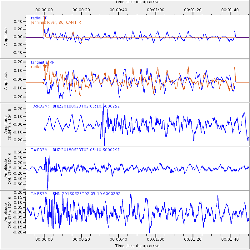
R33M Jennings River, BC, CAN - Earthquake Result Viewer
*The percent match for this event was below the threshold and hence no stack was calculated.
| Earthquake location: |
Near Coast Of Venezuela |
| Earthquake latitude/longitude: |
10.8/-62.6 |
| Earthquake time(UTC): |
2018/06/23 (174) 01:54:42 GMT |
| Earthquake Depth: |
106 km |
| Earthquake Magnitude: |
5.1 Mww |
| Earthquake Catalog/Contributor: |
NEIC PDE/us |
|
| Network: |
TA USArray Transportable Network (new EarthScope stations) |
| Station: |
R33M Jennings River, BC, CAN |
| Lat/Lon: |
59.39 N/130.97 W |
| Elevation: |
1437 m |
|
| Distance: |
69.8 deg |
| Az: |
329.56 deg |
| Baz: |
103.347 deg |
| Ray Param: |
$rayparam |
*The percent match for this event was below the threshold and hence was not used in the summary stack. |
|
| Radial Match: |
57.15087 % |
| Radial Bump: |
400 |
| Transverse Match: |
52.391747 % |
| Transverse Bump: |
400 |
| SOD ConfigId: |
13570011 |
| Insert Time: |
2019-04-30 11:03:54.841 +0000 |
| GWidth: |
2.5 |
| Max Bumps: |
400 |
| Tol: |
0.001 |
|
Signal To Noise
| Channel | StoN | STA | LTA |
| TA:R33M: :BHZ:20180623T02:05:10.600029Z | 4.4366302 | 2.6711695E-7 | 6.020717E-8 |
| TA:R33M: :BHN:20180623T02:05:10.600029Z | 1.6085715 | 9.182144E-8 | 5.70826E-8 |
| TA:R33M: :BHE:20180623T02:05:10.600029Z | 1.9859633 | 1.14532774E-7 | 5.7671144E-8 |
| Arrivals |
| Ps | |
| PpPs | |
| PsPs/PpSs | |


