You are here: Home > Network List > TA - USArray Transportable Network (new EarthScope stations) Stations List
> Station TUL3 Leonard, OK, USA > Earthquake Result Viewer
TUL3 Leonard, OK, USA - Earthquake Result Viewer
| Earthquake location: |
Near Coast Of Venezuela |
| Earthquake latitude/longitude: |
10.8/-62.6 |
| Earthquake time(UTC): |
2018/06/23 (174) 01:54:42 GMT |
| Earthquake Depth: |
106 km |
| Earthquake Magnitude: |
5.1 Mww |
| Earthquake Catalog/Contributor: |
NEIC PDE/us |
|
| Network: |
TA USArray Transportable Network (new EarthScope stations) |
| Station: |
TUL3 Leonard, OK, USA |
| Lat/Lon: |
35.91 N/95.79 W |
| Elevation: |
265 m |
|
| Distance: |
39.1 deg |
| Az: |
315.232 deg |
| Baz: |
121.522 deg |
| Ray Param: |
0.074827224 |
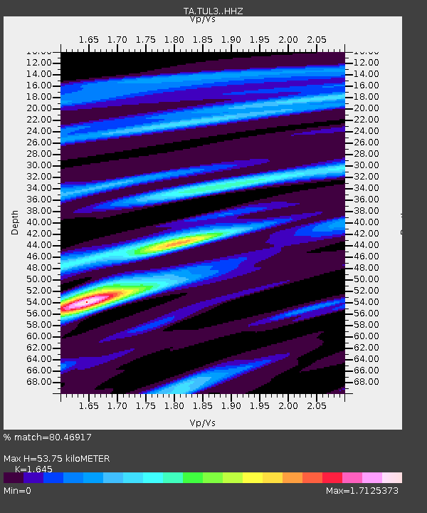
| Estimated Moho Depth: |
53.75 km |
| Estimated Crust Vp/Vs: |
1.64 |
| Assumed Crust Vp: |
6.498 km/s |
| Estimated Crust Vs: |
3.95 km/s |
| Estimated Crust Poisson's Ratio: |
0.21 |
|
| Radial Match: |
80.46917 % |
| Radial Bump: |
400 |
| Transverse Match: |
57.853394 % |
| Transverse Bump: |
400 |
| SOD ConfigId: |
13570011 |
| Insert Time: |
2019-04-30 11:04:02.694 +0000 |
| GWidth: |
2.5 |
| Max Bumps: |
400 |
| Tol: |
0.001 |
|
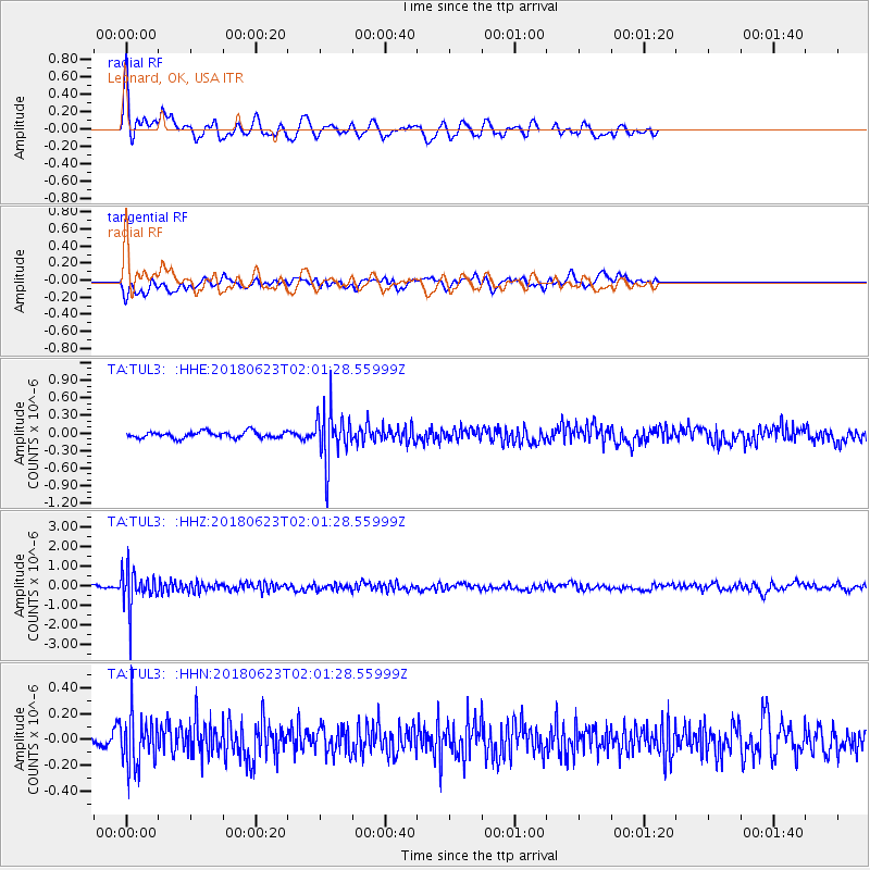
Signal To Noise
| Channel | StoN | STA | LTA |
| TA:TUL3: :HHZ:20180623T02:01:28.55999Z | 13.453004 | 9.4034834E-7 | 6.989877E-8 |
| TA:TUL3: :HHN:20180623T02:01:28.55999Z | 2.6305423 | 1.9585113E-7 | 7.445276E-8 |
| TA:TUL3: :HHE:20180623T02:01:28.55999Z | 7.815985 | 4.301923E-7 | 5.504006E-8 |
| Arrivals |
| Ps | 5.8 SECOND |
| PpPs | 20 SECOND |
| PsPs/PpSs | 26 SECOND |


