You are here: Home > Network List > AV - Alaska Volcano Observatory Stations List
> Station SPBG Barrier Glacier, Mount Spurr, Alaska > Earthquake Result Viewer
SPBG Barrier Glacier, Mount Spurr, Alaska - Earthquake Result Viewer
| Earthquake location: |
Central East Pacific Rise |
| Earthquake latitude/longitude: |
-9.0/-108.5 |
| Earthquake time(UTC): |
2018/06/24 (175) 18:43:42 GMT |
| Earthquake Depth: |
10 km |
| Earthquake Magnitude: |
5.7 Mww |
| Earthquake Catalog/Contributor: |
NEIC PDE/us |
|
| Network: |
AV Alaska Volcano Observatory |
| Station: |
SPBG Barrier Glacier, Mount Spurr, Alaska |
| Lat/Lon: |
61.26 N/152.37 W |
| Elevation: |
1087 m |
|
| Distance: |
78.0 deg |
| Az: |
339.989 deg |
| Baz: |
135.625 deg |
| Ray Param: |
0.049938142 |
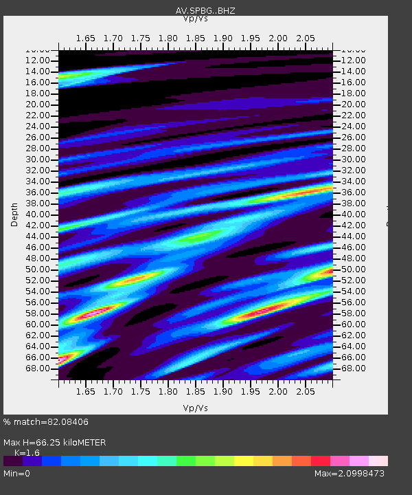
| Estimated Moho Depth: |
66.25 km |
| Estimated Crust Vp/Vs: |
1.60 |
| Assumed Crust Vp: |
6.566 km/s |
| Estimated Crust Vs: |
4.104 km/s |
| Estimated Crust Poisson's Ratio: |
0.18 |
|
| Radial Match: |
82.08406 % |
| Radial Bump: |
400 |
| Transverse Match: |
55.557507 % |
| Transverse Bump: |
400 |
| SOD ConfigId: |
13570011 |
| Insert Time: |
2019-04-30 11:08:14.444 +0000 |
| GWidth: |
2.5 |
| Max Bumps: |
400 |
| Tol: |
0.001 |
|

Signal To Noise
| Channel | StoN | STA | LTA |
| AV:SPBG: :BHZ:20180624T18:55:10.519019Z | 1.8032964 | 1.4908156E-7 | 8.267168E-8 |
| AV:SPBG: :BHN:20180624T18:55:10.519019Z | 1.2649864 | 1.0591528E-7 | 8.3728395E-8 |
| AV:SPBG: :BHE:20180624T18:55:10.519019Z | 1.7950575 | 1.5196245E-7 | 8.465603E-8 |
| Arrivals |
| Ps | 6.3 SECOND |
| PpPs | 25 SECOND |
| PsPs/PpSs | 32 SECOND |


