You are here: Home > Network List > TA - USArray Transportable Network (new EarthScope stations) Stations List
> Station H14A Leadore, ID, USA > Earthquake Result Viewer
H14A Leadore, ID, USA - Earthquake Result Viewer
| Earthquake location: |
Vanuatu Islands |
| Earthquake latitude/longitude: |
-13.5/167.0 |
| Earthquake time(UTC): |
2008/09/08 (252) 18:52:06 GMT |
| Earthquake Depth: |
110 km |
| Earthquake Magnitude: |
6.4 MB, 6.9 MW, 6.9 MW |
| Earthquake Catalog/Contributor: |
WHDF/NEIC |
|
| Network: |
TA USArray Transportable Network (new EarthScope stations) |
| Station: |
H14A Leadore, ID, USA |
| Lat/Lon: |
44.62 N/113.37 W |
| Elevation: |
1933 m |
|
| Distance: |
92.2 deg |
| Az: |
44.676 deg |
| Baz: |
253.26 deg |
| Ray Param: |
0.041452397 |
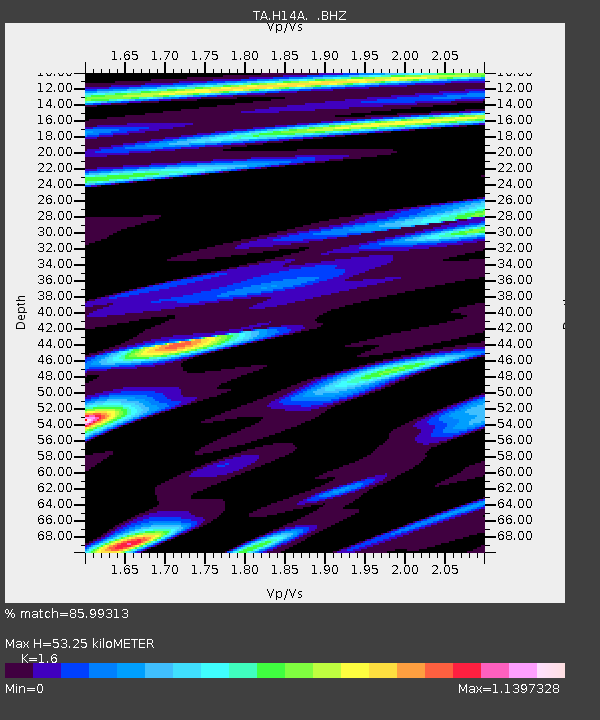
| Estimated Moho Depth: |
53.25 km |
| Estimated Crust Vp/Vs: |
1.60 |
| Assumed Crust Vp: |
6.577 km/s |
| Estimated Crust Vs: |
4.111 km/s |
| Estimated Crust Poisson's Ratio: |
0.18 |
|
| Radial Match: |
85.99313 % |
| Radial Bump: |
400 |
| Transverse Match: |
79.25194 % |
| Transverse Bump: |
400 |
| SOD ConfigId: |
2560 |
| Insert Time: |
2010-03-06 12:05:39.057 +0000 |
| GWidth: |
2.5 |
| Max Bumps: |
400 |
| Tol: |
0.001 |
|
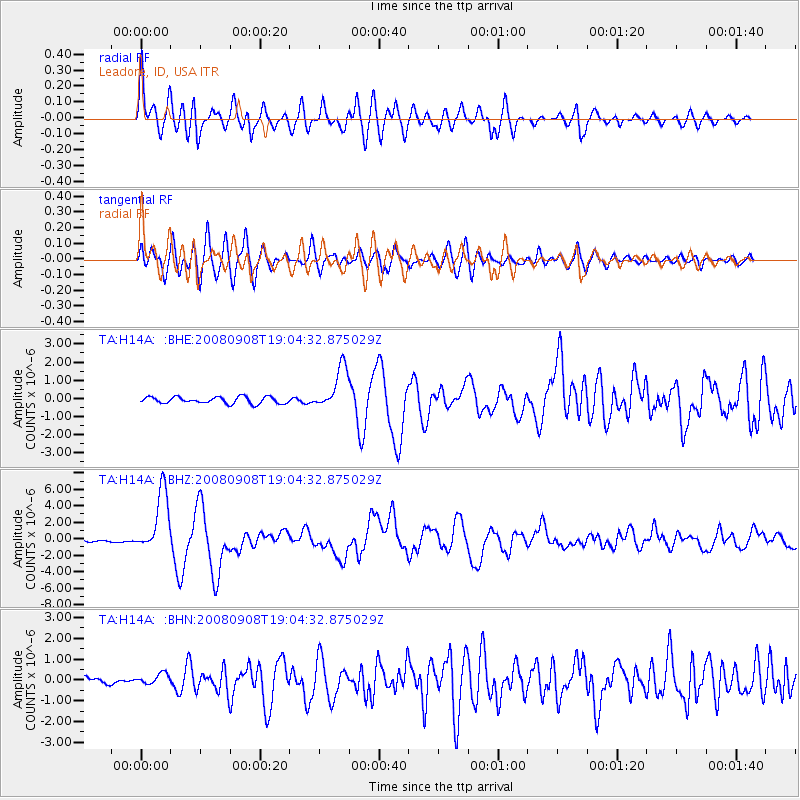
Signal To Noise
| Channel | StoN | STA | LTA |
| TA:H14A: :BHZ:20080908T19:04:32.875029Z | 30.282732 | 3.778194E-6 | 1.2476397E-7 |
| TA:H14A: :BHN:20080908T19:04:32.875029Z | 1.9227154 | 2.618119E-7 | 1.3616778E-7 |
| TA:H14A: :BHE:20080908T19:04:32.875029Z | 6.405157 | 1.1859709E-6 | 1.8515875E-7 |
| Arrivals |
| Ps | 5.0 SECOND |
| PpPs | 21 SECOND |
| PsPs/PpSs | 26 SECOND |


