You are here: Home > Network List > TA - USArray Transportable Network (new EarthScope stations) Stations List
> Station H14A Leadore, ID, USA > Earthquake Result Viewer
H14A Leadore, ID, USA - Earthquake Result Viewer
| Earthquake location: |
Santa Cruz Islands Region |
| Earthquake latitude/longitude: |
-11.0/164.5 |
| Earthquake time(UTC): |
2008/07/19 (201) 09:27:01 GMT |
| Earthquake Depth: |
11 km |
| Earthquake Magnitude: |
6.1 MB, 6.4 MS, 6.6 MW, 6.6 MW |
| Earthquake Catalog/Contributor: |
WHDF/NEIC |
|
| Network: |
TA USArray Transportable Network (new EarthScope stations) |
| Station: |
H14A Leadore, ID, USA |
| Lat/Lon: |
44.62 N/113.37 W |
| Elevation: |
1933 m |
|
| Distance: |
92.1 deg |
| Az: |
45.069 deg |
| Baz: |
256.701 deg |
| Ray Param: |
0.041503362 |
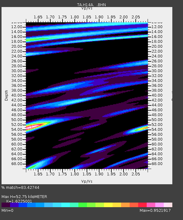
| Estimated Moho Depth: |
52.75 km |
| Estimated Crust Vp/Vs: |
1.62 |
| Assumed Crust Vp: |
6.577 km/s |
| Estimated Crust Vs: |
4.054 km/s |
| Estimated Crust Poisson's Ratio: |
0.19 |
|
| Radial Match: |
83.42744 % |
| Radial Bump: |
400 |
| Transverse Match: |
75.39743 % |
| Transverse Bump: |
400 |
| SOD ConfigId: |
2658 |
| Insert Time: |
2010-03-06 12:05:49.680 +0000 |
| GWidth: |
2.5 |
| Max Bumps: |
400 |
| Tol: |
0.001 |
|

Signal To Noise
| Channel | StoN | STA | LTA |
| TA:H14A: :BHN:20080719T09:39:39.199014Z | 24.429674 | 1.6954062E-6 | 6.939946E-8 |
| TA:H14A: :BHE:20080719T09:39:39.199014Z | 0.9276533 | 1.0216483E-7 | 1.10132554E-7 |
| TA:H14A: :BHZ:20080719T09:39:39.199014Z | 7.1198997 | 5.3027657E-7 | 7.4478095E-8 |
| Arrivals |
| Ps | 5.1 SECOND |
| PpPs | 21 SECOND |
| PsPs/PpSs | 26 SECOND |


