You are here: Home > Network List > TA - USArray Transportable Network (new EarthScope stations) Stations List
> Station H14A Leadore, ID, USA > Earthquake Result Viewer
H14A Leadore, ID, USA - Earthquake Result Viewer
| Earthquake location: |
Kermadec Islands Region |
| Earthquake latitude/longitude: |
-27.4/-176.3 |
| Earthquake time(UTC): |
2009/02/18 (049) 21:53:45 GMT |
| Earthquake Depth: |
25 km |
| Earthquake Magnitude: |
6.8 MB, 7.2 MS, 6.9 MW, 6.9 MW |
| Earthquake Catalog/Contributor: |
WHDF/NEIC |
|
| Network: |
TA USArray Transportable Network (new EarthScope stations) |
| Station: |
H14A Leadore, ID, USA |
| Lat/Lon: |
44.62 N/113.37 W |
| Elevation: |
1933 m |
|
| Distance: |
91.8 deg |
| Az: |
39.528 deg |
| Baz: |
232.386 deg |
| Ray Param: |
0.04154349 |
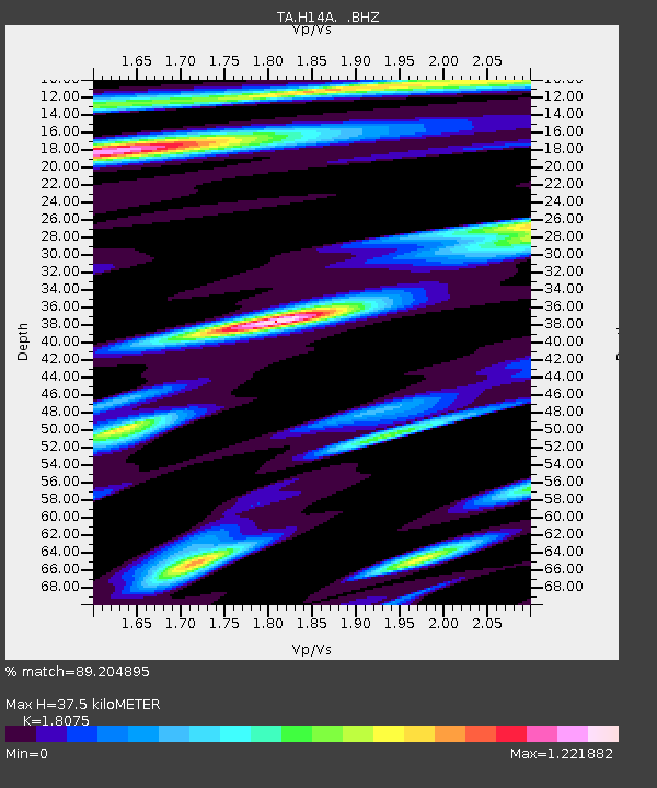
| Estimated Moho Depth: |
37.5 km |
| Estimated Crust Vp/Vs: |
1.81 |
| Assumed Crust Vp: |
6.577 km/s |
| Estimated Crust Vs: |
3.639 km/s |
| Estimated Crust Poisson's Ratio: |
0.28 |
|
| Radial Match: |
89.204895 % |
| Radial Bump: |
400 |
| Transverse Match: |
85.71323 % |
| Transverse Bump: |
400 |
| SOD ConfigId: |
2658 |
| Insert Time: |
2010-03-06 12:05:54.449 +0000 |
| GWidth: |
2.5 |
| Max Bumps: |
400 |
| Tol: |
0.001 |
|

Signal To Noise
| Channel | StoN | STA | LTA |
| TA:H14A: :BHZ:20090218T22:06:19.449001Z | 4.778941 | 1.3511707E-6 | 2.827343E-7 |
| TA:H14A: :BHN:20090218T22:06:19.449001Z | 1.2364137 | 3.250475E-7 | 2.6289544E-7 |
| TA:H14A: :BHE:20090218T22:06:19.449001Z | 1.726504 | 5.365127E-7 | 3.1075092E-7 |
| Arrivals |
| Ps | 4.7 SECOND |
| PpPs | 16 SECOND |
| PsPs/PpSs | 20 SECOND |


