You are here: Home > Network List > TA - USArray Transportable Network (new EarthScope stations) Stations List
> Station H14A Leadore, ID, USA > Earthquake Result Viewer
H14A Leadore, ID, USA - Earthquake Result Viewer
| Earthquake location: |
Kuril Islands |
| Earthquake latitude/longitude: |
46.0/151.4 |
| Earthquake time(UTC): |
2009/04/18 (108) 19:17:58 GMT |
| Earthquake Depth: |
35 km |
| Earthquake Magnitude: |
6.3 MB, 6.3 MS, 6.6 MW, 6.4 MW |
| Earthquake Catalog/Contributor: |
WHDF/NEIC |
|
| Network: |
TA USArray Transportable Network (new EarthScope stations) |
| Station: |
H14A Leadore, ID, USA |
| Lat/Lon: |
44.62 N/113.37 W |
| Elevation: |
1933 m |
|
| Distance: |
62.8 deg |
| Az: |
53.087 deg |
| Baz: |
308.723 deg |
| Ray Param: |
0.05992074 |
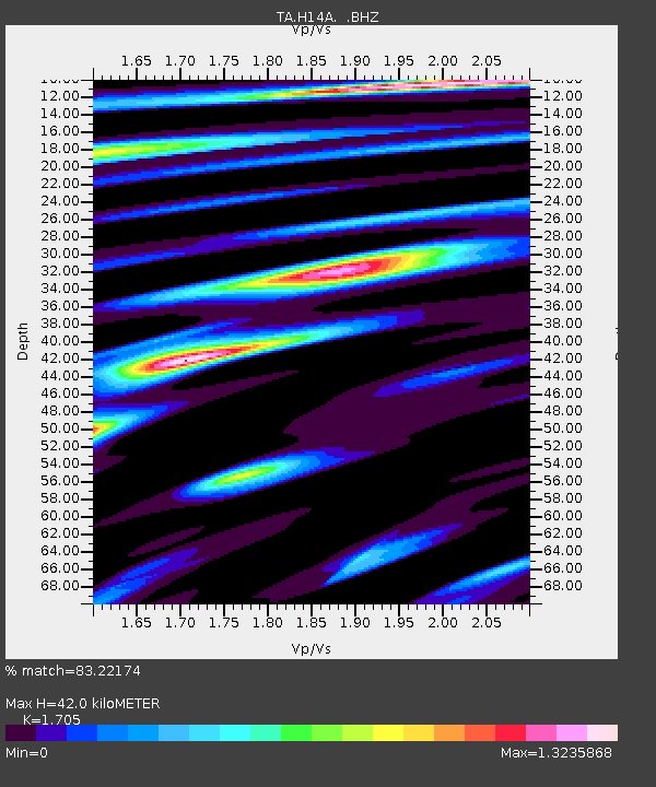
| Estimated Moho Depth: |
42.0 km |
| Estimated Crust Vp/Vs: |
1.71 |
| Assumed Crust Vp: |
6.577 km/s |
| Estimated Crust Vs: |
3.857 km/s |
| Estimated Crust Poisson's Ratio: |
0.24 |
|
| Radial Match: |
83.22174 % |
| Radial Bump: |
400 |
| Transverse Match: |
79.25382 % |
| Transverse Bump: |
400 |
| SOD ConfigId: |
2760 |
| Insert Time: |
2010-03-06 12:06:42.364 +0000 |
| GWidth: |
2.5 |
| Max Bumps: |
400 |
| Tol: |
0.001 |
|
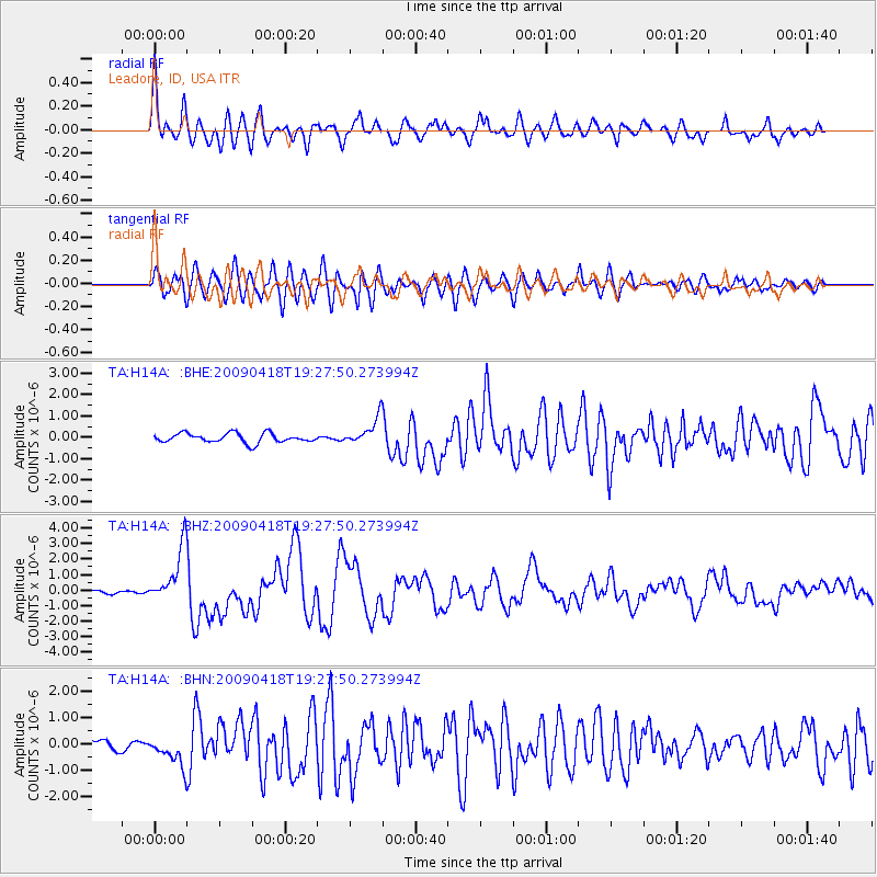
Signal To Noise
| Channel | StoN | STA | LTA |
| TA:H14A: :BHZ:20090418T19:27:50.273994Z | 13.307083 | 1.804696E-6 | 1.356192E-7 |
| TA:H14A: :BHN:20090418T19:27:50.273994Z | 2.5734506 | 5.169104E-7 | 2.0086277E-7 |
| TA:H14A: :BHE:20090418T19:27:50.273994Z | 2.8212984 | 6.243912E-7 | 2.2131341E-7 |
| Arrivals |
| Ps | 4.7 SECOND |
| PpPs | 16 SECOND |
| PsPs/PpSs | 21 SECOND |


