You are here: Home > Network List > TA - USArray Transportable Network (new EarthScope stations) Stations List
> Station H14A Leadore, ID, USA > Earthquake Result Viewer
H14A Leadore, ID, USA - Earthquake Result Viewer
| Earthquake location: |
Solomon Islands |
| Earthquake latitude/longitude: |
-10.5/161.3 |
| Earthquake time(UTC): |
2008/06/03 (155) 16:20:50 GMT |
| Earthquake Depth: |
84 km |
| Earthquake Magnitude: |
6.2 MB, 6.2 MW, 6.2 MW |
| Earthquake Catalog/Contributor: |
WHDF/NEIC |
|
| Network: |
TA USArray Transportable Network (new EarthScope stations) |
| Station: |
H14A Leadore, ID, USA |
| Lat/Lon: |
44.62 N/113.37 W |
| Elevation: |
1933 m |
|
| Distance: |
94.0 deg |
| Az: |
45.528 deg |
| Baz: |
259.306 deg |
| Ray Param: |
0.041091643 |
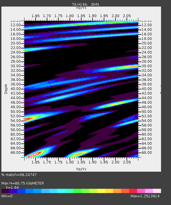
| Estimated Moho Depth: |
68.75 km |
| Estimated Crust Vp/Vs: |
1.64 |
| Assumed Crust Vp: |
6.577 km/s |
| Estimated Crust Vs: |
4.01 km/s |
| Estimated Crust Poisson's Ratio: |
0.20 |
|
| Radial Match: |
86.24747 % |
| Radial Bump: |
400 |
| Transverse Match: |
80.26896 % |
| Transverse Bump: |
400 |
| SOD ConfigId: |
2504 |
| Insert Time: |
2010-03-06 12:07:08.737 +0000 |
| GWidth: |
2.5 |
| Max Bumps: |
400 |
| Tol: |
0.001 |
|

Signal To Noise
| Channel | StoN | STA | LTA |
| TA:H14A: :BHN:20080603T16:33:27.77502Z | 23.250698 | 1.3032709E-6 | 5.6052976E-8 |
| TA:H14A: :BHE:20080603T16:33:27.77502Z | 3.1839194 | 1.676401E-7 | 5.2652116E-8 |
| TA:H14A: :BHZ:20080603T16:33:27.77502Z | 5.4481907 | 3.1289517E-7 | 5.7431023E-8 |
| Arrivals |
| Ps | 6.8 SECOND |
| PpPs | 27 SECOND |
| PsPs/PpSs | 34 SECOND |


