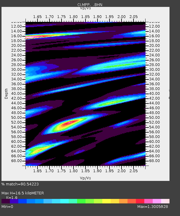
MPP McPhearson Peak - Earthquake Result Viewer
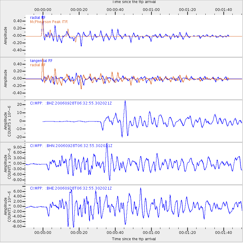
Earthquake location: Samoa Islands Region
Earthquake latitude/longitude: -16.6/-172.0
Earthquake time(UTC): 2006/09/28 (271) 06:22:09 GMT
Earthquake Depth: 28 km
Earthquake Magnitude: 6.5 MB, 6.6 MS, 6.9 MW, 6.7 MW
Earthquake Catalog/Contributor: WHDF/NEIC
Network: CI Caltech Regional Seismic Network
Station: MPP McPhearson Peak
Lat/Lon: 34.89 N/119.81 W
Elevation: 1739 m
Distance: 71.3 deg
Az: 43.323 deg
Baz: 233.16 deg
Ray Param: 0.054411057
Estimated Moho Depth: 16.5 km
Estimated Crust Vp/Vs: 1.60
Assumed Crust Vp: 6.1 km/s
Estimated Crust Vs: 3.812 km/s
Estimated Crust Poisson's Ratio: 0.18
Radial Match: 90.54223 %
Radial Bump: 400
Transverse Match: 84.92296 %
Transverse Bump: 400
SOD ConfigId: 2665
Insert Time: 2010-02-26 02:02:04.984 +0000
GWidth: 2.5
Max Bumps: 400
Tol: 0.001

Signal To Noise

ChannelStoNSTALTA
CI:MPP: :BHN:20060928T06:32:55.302021Z6.2534071.2355302E-61.9757712E-7
CI:MPP: :BHE:20060928T06:32:55.302021Z7.50939371.3612544E-61.8127353E-7
CI:MPP: :BHZ:20060928T06:32:55.302021Z16.1571873.9363017E-62.4362544E-7
Arrivals
Ps1.7 SECOND
PpPs6.8 SECOND
PsPs/PpSs8.5 SECOND