You are here: Home > Network List > TA - USArray Transportable Network (new EarthScope stations) Stations List
> Station F26K Sheenjek River, AK, USA > Earthquake Result Viewer
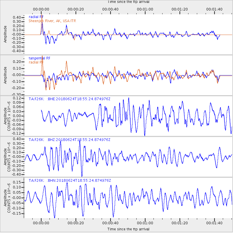
F26K Sheenjek River, AK, USA - Earthquake Result Viewer
*The percent match for this event was below the threshold and hence no stack was calculated.
| Earthquake location: |
Central East Pacific Rise |
| Earthquake latitude/longitude: |
-9.0/-108.5 |
| Earthquake time(UTC): |
2018/06/24 (175) 18:43:42 GMT |
| Earthquake Depth: |
10 km |
| Earthquake Magnitude: |
5.7 Mww |
| Earthquake Catalog/Contributor: |
NEIC PDE/us |
|
| Network: |
TA USArray Transportable Network (new EarthScope stations) |
| Station: |
F26K Sheenjek River, AK, USA |
| Lat/Lon: |
67.69 N/144.15 W |
| Elevation: |
683 m |
|
| Distance: |
80.7 deg |
| Az: |
346.983 deg |
| Baz: |
144.351 deg |
| Ray Param: |
$rayparam |
*The percent match for this event was below the threshold and hence was not used in the summary stack. |
|
| Radial Match: |
73.174255 % |
| Radial Bump: |
400 |
| Transverse Match: |
56.83451 % |
| Transverse Bump: |
400 |
| SOD ConfigId: |
13570011 |
| Insert Time: |
2019-04-30 11:16:23.710 +0000 |
| GWidth: |
2.5 |
| Max Bumps: |
400 |
| Tol: |
0.001 |
|
Signal To Noise
| Channel | StoN | STA | LTA |
| TA:F26K: :BHZ:20180624T18:55:24.874976Z | 2.673036 | 1.355944E-7 | 5.0726737E-8 |
| TA:F26K: :BHN:20180624T18:55:24.874976Z | 2.9011705 | 8.008249E-8 | 2.7603512E-8 |
| TA:F26K: :BHE:20180624T18:55:24.874976Z | 2.073689 | 5.0082267E-8 | 2.415129E-8 |
| Arrivals |
| Ps | |
| PpPs | |
| PsPs/PpSs | |


