You are here: Home > Network List > IW - Intermountain West Stations List
> Station MOOW Moose Ponds, Wyoming, USA > Earthquake Result Viewer
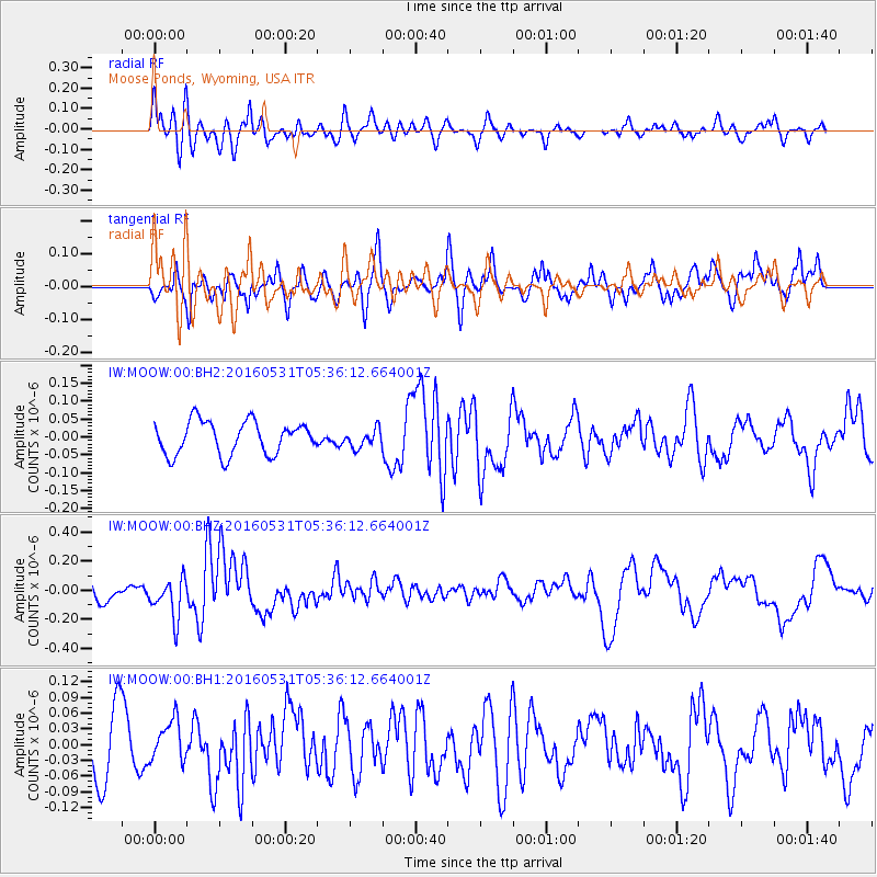
MOOW Moose Ponds, Wyoming, USA - Earthquake Result Viewer
*The percent match for this event was below the threshold and hence no stack was calculated.
| Earthquake location: |
Taiwan Region |
| Earthquake latitude/longitude: |
25.6/122.5 |
| Earthquake time(UTC): |
2016/05/31 (152) 05:23:47 GMT |
| Earthquake Depth: |
243 km |
| Earthquake Magnitude: |
6.1 MO |
| Earthquake Catalog/Contributor: |
NEIC PDE/NEIC ALERT |
|
| Network: |
IW Intermountain West |
| Station: |
MOOW Moose Ponds, Wyoming, USA |
| Lat/Lon: |
43.75 N/110.74 W |
| Elevation: |
2128 m |
|
| Distance: |
95.5 deg |
| Az: |
35.692 deg |
| Baz: |
313.356 deg |
| Ray Param: |
$rayparam |
*The percent match for this event was below the threshold and hence was not used in the summary stack. |
|
| Radial Match: |
53.223866 % |
| Radial Bump: |
400 |
| Transverse Match: |
69.91189 % |
| Transverse Bump: |
400 |
| SOD ConfigId: |
1475611 |
| Insert Time: |
2016-06-14 05:27:17.076 +0000 |
| GWidth: |
2.5 |
| Max Bumps: |
400 |
| Tol: |
0.001 |
|
Signal To Noise
| Channel | StoN | STA | LTA |
| IW:MOOW:00:BHZ:20160531T05:36:12.664001Z | 2.21664 | 1.3676747E-7 | 6.170035E-8 |
| IW:MOOW:00:BH1:20160531T05:36:12.664001Z | 0.70090836 | 3.92483E-8 | 5.599634E-8 |
| IW:MOOW:00:BH2:20160531T05:36:12.664001Z | 0.5496484 | 2.5260666E-8 | 4.5957865E-8 |
| Arrivals |
| Ps | |
| PpPs | |
| PsPs/PpSs | |


